
Ancient Cypriot Architecture·Lesson 12
How Buildings Fall
Earthquake, fire, neglect and the stone-robber brought Cypriot buildings down. Read the fallen wall, the burnt roof and the empty floor, and the debris gives back how tall a building stood and how it was roofed, though rarely why it fell.
Alexis Drakopoulos·Across the periods·13 min read
Share


Lesson 12·Course contents, 14 lessons
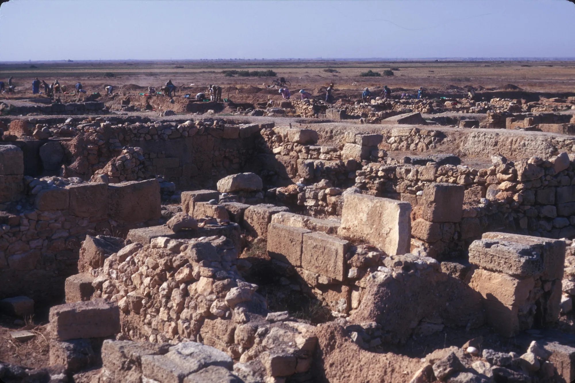
On 5 June 1934 John Franklin Daniel, cutting a trial trench across the acropolis of Kourion for the University of Pennsylvania, reached a floor with pots and a lamp lying on it. His notebook entry for the day runs to five sentences: "Find clay pot, bronze pitcher, broken lamp, and part of another pot directly on the floor. Next to these, also on the floor, a human skeleton. This was not a burial. The person seems to have been standing when the house fell, and crushed where he stood. As there are no signs of fire an earthquake may have caused the disaster." [1, p. 20 n. 146]
Daniel looked at what lay on the floor and what lay on top of it, ruled out a grave and then a fire, and kept his verb at "may". Fifty years later a University of Arizona team under David Soren dug the rest of the building, now called the Earthquake House, and confirmed his reading [2; 1].
Lesson 0 listed what a Cypriot building loses before anyone digs it: the roof, the upper walls, the timber, the upper floor. What survives of those parts survives as debris, so a collapse is our best witness to how a building stood: how tall its walls were, how it was roofed, what was kept upstairs. It is a far weaker witness to why it fell. An earthquake, a fire, an attack and fifty years of neglect can leave very similar heaps, and Cypriot archaeology has often reached for the earthquake first.
Slow ends: rain, salvage and the stone-robber
Most buildings simply wore out. The flat earth roof of Lesson 1, as Stuart Swiny describes it from Cypriot village houses, was beams, reeds or branches, brush, earth and mud plaster, sealed with a thin skin of tamped clay "renewed every year": 20 to 40 cm thick and about 500 kg on every square metre [3, p. 57]. Stop renewing the skin and water reaches the timbers. They rot, the roof sags into the room, and the wall tops lie open to the rain. A mudbrick wall in that state slumps into a mound of soil against its own socle, the stone base course. At the Earthquake House only stone footings stand, yet the rooms were full of "decayed mudbrick": the walls were stone below and brick above, and Benjamin Costello, who published the house in 2014, rejects the 1980s drawings of it in stone throughout [1, p. 31].
People also came back for what was useful. Swiny watched it in villages of the Kyrenia district abandoned in 1974: "serviceable beams are normally retrieved after removal of the soil covering" [3, p. 53 n. 1]. Hence so few charred beams: at Kaminoudhia, where parts of the village burned, Swiny found "no partially charred beams nor the telltale impressions of reeds or brushwood on fire-hardened clay" [3, p. 57]. Salvage leaves its own signature, an empty floor. At several Late Bronze Age towns, Maroni and Alassa among them, the final abandonment looks organised, with little left on the floors [12].
Stone went the same way. At Kition stone-robbers took most of the ashlar (squared, dressed blocks) from the earlier walls of Temple 4, leaving only the foundations to give its plan [11]. The builders of the Pithos House at Kissonerga, sometime between about 2700 and 2500 BC, used blocks of calcarenite, a sandy limestone, probably robbed from the ruined Red Building nearby [7]. The Earthquake House itself reused older buildings: column drums and querns in its walls, an upside-down pilaster capital as a step [1, pp. 34-36]. In excavation a robbed wall shows up as a trench of loose soil and chips where the wall should be, or as foundations with nothing on top.
Floors on top of floors
When a house fell, the people who stayed often levelled the debris and built on it. At Khirokitia, Porphyrios Dikaios found that the collapsed superstructure of a round house (he called them tholoi) was often left in place under the next floor; in Tholos XLVII the layers between floors are 0.24 to 0.45 m thick. Sometimes the occupants cleared it out instead, "to avoid losing internal height" [6]. XLVII has eight floors, and Tholos XV(II) twelve. By its last phase the threshold of XLVII sat 1.70 m above its earliest floor [6].
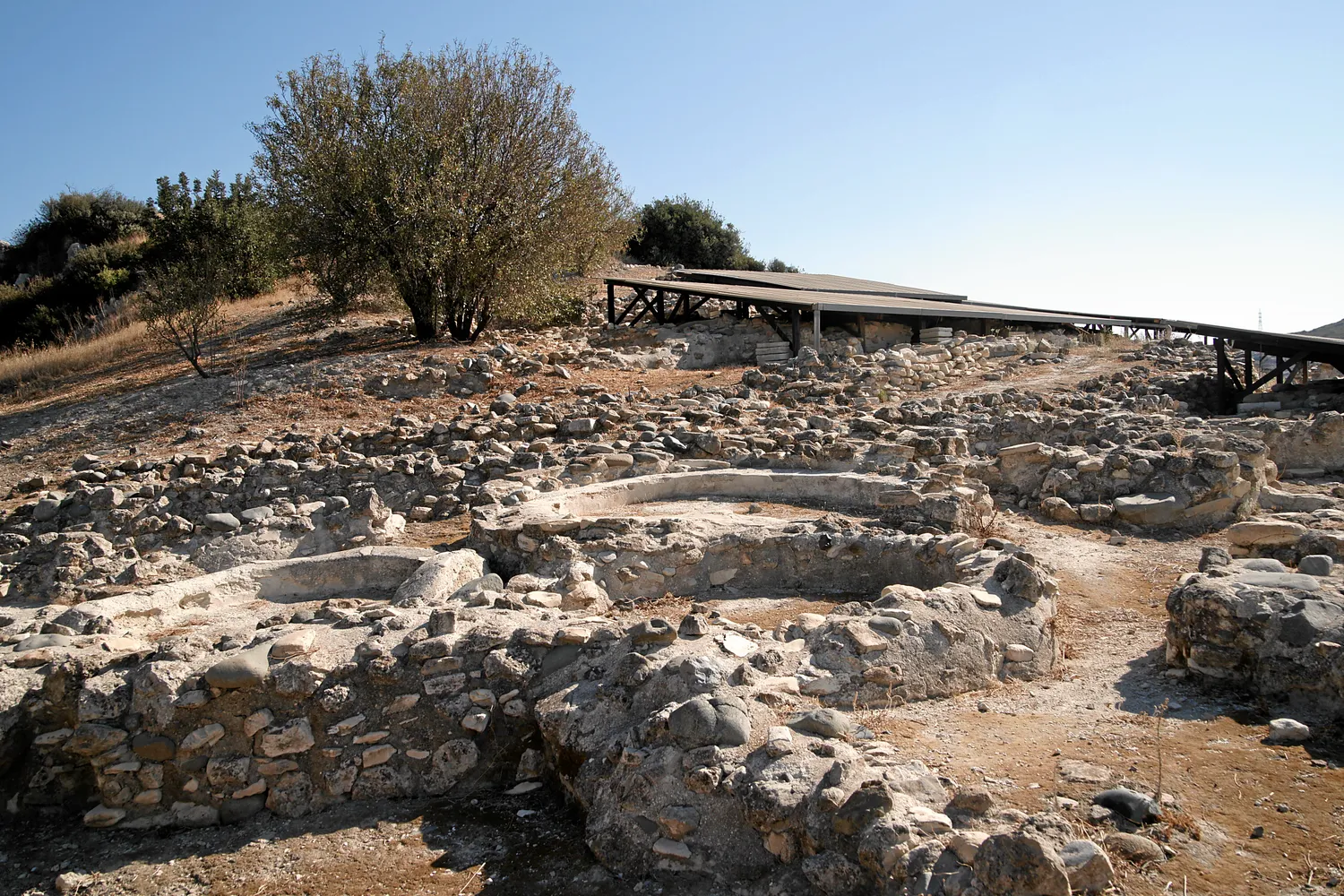
Repeat that across a village for centuries and the settlement rises on its own debris into a tell, a mound built of its collapsed houses. At Marki-Alonia, in the Early and Middle Bronze Age, rebuilders cleared the old brick away, cut the floors down 20 to 30 cm and set new walls on the old stumps [13], so a footing standing more than a metre high there may be two or three socles stacked. At Kition a layer of red mudbrick from the old city wall, spread and capped with havara (the soft white chalk and marl of the Cypriot lowlands, long used for floors and roofs), forms the ground under Temples 1 and 2 [11].
The debris sealing one floor under the next is a gift to the excavator: everything beneath belongs to the life of the room below, and nothing later reaches it unless someone digs a pit.
A wall that fell in one piece
Around 2200 BC, in Early Cypriot III, the village of Sotira-Kaminoudhia was abandoned and never lived in again [3, pp. 53, 66]. Some of its walls had come down as whole panels. In Unit 1, wall WI lay downslope to the south, up to ten courses "stacked like fallen dominos at 45°", each stone still in its course [3, p. 11]. Nine of the fallen stones measure 12 to 15 cm each, 117 cm in all; add at least 3.5 cm of mud mortar for each course and the 45 cm stub still standing, and the wall stood at least 1.93 m. A second wall, WH, gives at least 3.04 m. Swiny concluded that the walls "stood to at least 2 m and probably closer to 3 m in height, without any use of mudbrick or pisé", pisé being mud packed in layers without moulds [3, pp. 11, 56].
The drawing lays both fallen walls out as they were found and stands each back up on its stub, course by course.
Key to the line styles and hatching
Line: how well it is known
- ExcavatedMeasured on excavated remains
- Strong inferenceIndirect but good evidence
- ReconstructionWorked out from experiment, engineering or parallels
- SpeculativeNo direct evidence
- RejectedRuled out by the evidence; shown for comparison
Hatching: material
- Tabular limestone, cut
- Stone, seen
- Bedrock
- Ground outside
- Trodden floor debris
- Lime plaster
- Mud plaster, mud sills
- Dry earth (roof)
- Brush
- Reeds (roof bed or thatch)
- Timber, along the grain
- Timber, cut across
Scroll sideways to see the whole plate
Drawing from A Stone House at Sotira-Kaminoudhia, fig. 5.
The arithmetic holds whatever brought the wall down, which matters, because the cause is disputed. Swiny read the consistent southward fall as an earthquake followed by a fire, and the geologist George Rapp independently called it "a possible earthquake" [3, pp. 53-54, 465-466]. But the village sits on terraces sloping south, and Swiny himself describes walls in another unit "tilted southwards due to slope pressure", and WI toppling downslope "after the structure was abandoned" [3, pp. 11, 21]. Slow creep would also throw walls to the south. The fallen courses measure the wall; what pushed it over is a separate question.
A roof that fell in one piece
At Khirokitia, a Late Aceramic Neolithic village of round houses, a small building numbered S.85, 1.85 m across inside, burned early in its life, and the fire brought its roof down "en un seul bloc", in one piece, leaving the floor covered with fragments of fire-hardened earth 5 to 8 cm thick. One face of each was flat and smooth; the other carried the negative impressions of branches and reeds laid side by side, and in the great majority of fragments the impressed face lay downward. Alain Le Brun read the roof directly from them: a flat terrace of branches and reeds under layers of earth, carried on wooden bearers resting on the wall top, since the floor had no post-holes [5].
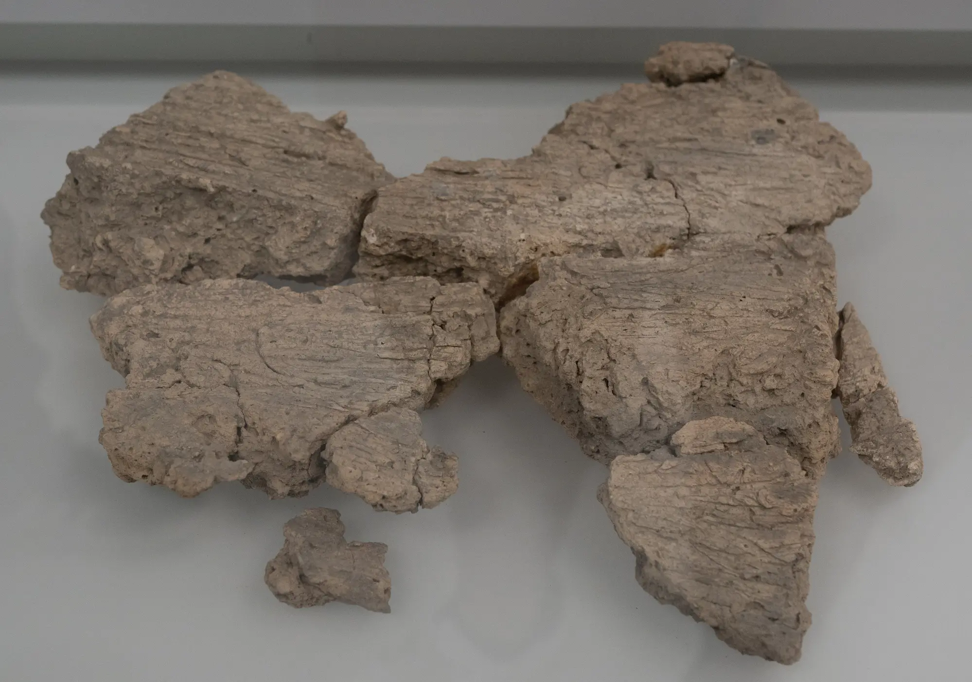
Roof fragments from Khirokitia with these impressions are displayed in the Larnaca District Museum [4], and they settled an argument. Dikaios, who excavated Khirokitia between 1936 and 1946, had seen the upper parts of some walls leaning inwards and took them for the springing of mudbrick domes; the inward curve of Tholos XLVII was, he wrote, "a convincing proof" of how the houses were roofed [6]. Le Brun answered that a true vault leaves overlapping, corbelled courses, and none were visible; that a mudbrick wall north of XLVII leaned to the south at exactly the same angle as the supposed dome; and that on a steep hillside the pressure of the earth behind a wall pushes its upper part over [4]. The "dome" was a wall that had begun to fall. The flat roof came from the fallen roof itself.
The order of the fall
A burnt building that nobody cleared keeps the sequence of its collapse in its layers, bottom to top. Building 3 at Kissonerga-Mosphilia, the Pithos House of the Late Chalcolithic (Lesson 3), was a round room 9.1 m across with at least 37 storage vessels on its floor [7]. Directly on it lay ash with the stains of burnt timbers, some "aligned with postholes, as if fallen from those positions"; above them, fragments of roof clay printed with reeds; on top, fire-blackened stones and compacted mud from the upper walls, which had "crashed down onto the pithoi", the big storage jars, "in such a way that sherds and stones became inextricably mixed". The excavators read it plainly: "the roof collapsed and stones and compacted mud from the upper walls followed subsequently" [7]. The body of a small child lay trapped in the western collapse of the upper wall and roof.
Open the house at the moment its roof gives way and step on through the fire: the timbers come down first, some in line with their posts, then the slabs of reed-printed roof clay, and last the stones of the upper walls onto the jars. Two stops on, the heap lies as the excavators found it.
Opens on the guided tour, stop 12 of 15: fire: the roof falls.
The Pithos House at Kissonerga
Open the full reconstructionc. 2700 to 2500 BC · Kissonerga-Mosphilia
The fire in the Pithos House at Kissonerga, in the order the layers give. How it started is not shown, because nobody knows.
The volume of fallen stone also told Gordon Thomas, who studied the building's structure, that its wall was stone almost to the top, which the 0.78 m still standing could never show [7]. The cause of the fire stays open. The excavators in 1998 thought of an accident fed by stored oil, while allowing that it might have been arson. Edgar Peltenburg later wrote that it was deliberately burnt [8]; Bleda Düring argues that houses of stone and mud burn badly, so fuel was probably added on purpose [9]. Nobody dug back into the Pithos House for its jars. A smaller oval house went up on the levelled ruin, its door almost exactly over the old door [7].
Same heap, different causes
Archaeoseismology, the study of ancient earthquakes from the damage they left, looks for signs hard to produce any other way: people and animals caught under fallen walls, columns lying parallel where a wave of shaking threw them, walls pushed out of line, damage across a whole region at one date. War leaves weapons in the debris. Fire leaves ash, but a shaking house with lamps and hearths can burn too, so ash alone settles nothing.
Enkomi shows how hard the sorting gets. When the Late Cypriot III phase that Dikaios called Level IIIB ended, mudbrick walls collapsed into a layer some 0.80 m thick. In Room 9 a doorjamb fell westward and stayed tilted in the mass of brick, and in Room 8 a child's skeleton lay under the debris. Dikaios concluded that an earthquake had struck [10; 15, p. 251]. Yet in Area III, in the same destruction, he recorded repairs to the fortifications and heaps of sea pebbles and sling bullets, the ammunition of a town expecting attack. And two more children, in Room 2, had by his own account been dumped there after the catastrophe, so they are no evidence for how it happened [10; 15, p. 251]. Igor Kreimerman's review of the island's Late Bronze Age destructions finds that their extent and dates vary, so they "cannot be the result of a single event"; most towns ended in gradual abandonment, and those destroyed outright were mostly rebuilt [12].
Kition gives the strongest prehistoric case for an earthquake. In the second quarter of the 11th century BC the mudbrick upper wall of the city fell onto the street beside it, and large parts of it, complete bricks included, were found "exactly as they fell", sealing pottery of that date; neither wall nor street was rebuilt. Workshop roofs fell on the storage jars beneath, and the ashlar foundations of a temple gateway broke in two. Vassos Karageorghis blamed "a physical phenomenon, probably an earthquake" [11]. His further claim, that the same event ended every Late Bronze Age town on the island, goes beyond what the dates allow.
The Earthquake House
Kourion is the clearest case on the island, because there the evidence comes from several sides at once. Seven people died in the house: two adults in Room 1, where Daniel's trench had found them, a girl of about thirteen in Room 2, a man in his fifties in Room 11 beside the hall, and a young woman, a man and an infant together in Room 20 [1, pp. 97, 106]. In the stable a mule still lay tethered by an iron chain to its stone trough [1, p. 58]. Daniel had seen no sign of fire, and nobody came back to dig out the dead or loot their belongings [1, p. 44].
The collapse also rebuilt the house. Room 8, a hall 7.65 by 6.40 m, was the only room with a tiled roof; the excavators counted tile corners and found the full set [1, p. 34; 2]. The tiles lay as one layer, the clearest boundary in the house between earthquake debris and everything that settled later, with a band along the walls where none lay [1, pp. 34, 45, 47]. They had slid inwards off a roof that sagged as its central post buckled. That post, two column drums on a stack of six slabs, stood 3.24 m high, and impressions of overlapping tiles in the lime plaster that bonded them gave a pitch of about 22.5 degrees [1, pp. 34-35, n. 215]. The other rooms had flat earth roofs, and one piece of fallen roof plaster still bore the impression of reeds [1, p. 32; 14]. In Room 2, the stable, a bronze lampstand, a marble tabletop and some 170 coins lay in the debris over the mule, fallen from a room above, and the girl lay over the mule's hindquarters. Soren pictured her crawling up through the rubble between shocks; Costello reads her position as a fall with the collapsing upper floor [1, pp. 58-59, 89 n. 387; 2].
Open the house at the first shock and look down into the hall: the post has buckled, the tiles have slid inwards off both slopes, and a bare band runs along the walls. Step on to the next stop to watch the upper floor drop into the stable.
Opens on the guided tour, stop 11 of 15: the first wave. Loads about 9 MB (2 MB on phones).
The Earthquake House at Kourion
Open the full reconstructionlater 4th century AD · Kourion
The Earthquake House as its roofs came down. The tile layer and the bare band along the hall walls are excavated; the waves of shaking follow Soren's team's reading, described below.
Soren's team went further and read the shaking from the layers in Room 8: a first wave of about four seconds, a pause, a killing second wave of about ten, perhaps a weaker third, all estimates by their seismologist, Terry Wallace, who himself doubted the third [2]. The house had been shaken before: kitchen walls patched with amphora sherds, the courtyard colonnade already fallen and its drums stacked [1, pp. 36, 41]. The date is disputed too. Soren tied the destruction to the great earthquake off Crete on 21 July AD 365, from the latest coins; Costello calls that identification "convincingly challenged and largely invalidated", since the Cretan rupture lay some 860 km away, and prefers a separate Cypriot earthquake around AD 370 to 380 [1, p. 15]. The secure statement is the later 4th century AD.
Daniel's trench was backfilled when the 1934 dig moved on to the basilica and the theatre. The other five of the house's dead stayed where the walls had dropped them, under the yellow soil the wind laid over the ruins, until Soren's team came back [1].
Quiz
Check yourself
Question
Wall WI at Sotira-Kaminoudhia fell as a panel. Its nine fallen stones measure 117 cm in all, each course had at least 3.5 cm of mud mortar, and 45 cm of the wall still stands. At least how tall did it stand, in metres?
Question
The fallen walls at Sotira-Kaminoudhia all lie to the south. Why does that not prove an earthquake?
Question
Put the layers in the burnt Pithos House at Kissonerga in order, from the floor up.
Tap an item, then tap its place. Or use the arrows
Question
The burnt roof of house S.85 at Khirokitia lay on the floor in fragments, most with their reed-printed face downward. What did they show?
Question
How well do we know each part of the Earthquake House story? Sort the statements.
Tap a statement, then the bin it belongs in
To sort (5)
Question
At Enkomi, which find in the Level IIIB destruction points away from an earthquake?
Question
You excavate a room whose floor is almost empty, with no charred beams in the debris. What is the likeliest reading?
What to look for
- A low stone wall with a broad apron of loose soil and few stones at its foot was probably the socle of a mudbrick wall; the brick has melted into the soil around it.
- Stones lying in rows on edge beside a wall, still in their courses, are the wall itself fallen as a panel: count the courses, add the mortar and the standing stub, and you have its least height.
- Burnt clay with reed or branch impressions on one face is roof; the direction of the impressions and which way the impressed face lies tell how the roof was built.
- In a burnt room the order of the layers is the order of the fall: timbers and ash on the floor, roof clay above, wall stones on top.
- A floor with whole vessels, tools and people under the debris points to a sudden end; an empty floor points to people who left and took what they could carry.
- Weapons, sling bullets and repaired defences in a destruction layer point to war; walls fallen together on people left where they lay point to an earthquake. Most layers give mixed signals.
- A trench of loose fill where a wall should be, or bare foundations with nothing above, is the work of stone-robbers.
Go deeper
Take the three collapses apart in the reconstructions of the Earthquake House at Kourion, the Pithos House at Kissonerga and the stone house at Sotira-Kaminoudhia, and see the flat roof that replaced the dome in the Khirokitia household. The compendium's page on earthquakes covers the island's recorded quakes, and the site pages for Kourion, Khirokitia, Enkomi and Kition carry the excavations further.
References
- 1.Costello IV, B. (2014). Architecture and Material Culture from the Earthquake House at Kourion, Cyprus: A Late Roman Non-Elite House Destroyed in the 4th Century AD. BAR International Series 2635. Oxford: Archaeopress.
- 2.Soren, D. and James, J. (1988). Kourion: The Search for a Lost Roman City. New York: Anchor Press/Doubleday.
- 3.Swiny, S., Rapp, G. and Herscher, E. (eds) (2003). Sotira Kaminoudhia: An Early Bronze Age Site in Cyprus. ASOR Archaeological Reports 8 / CAARI Monograph 4. Boston: American Schools of Oriental Research. (Swiny, 'The settlement', ch. 2; Rapp, 'Geologic and geomorphic setting and resources', ch. 14.)
- 4.Le Brun, A. (1997). Khirokitia: A Neolithic Site. Nicosia: Bank of Cyprus Cultural Foundation. (With S. Hadjisavvas on the reconstructed houses.)
- 5.Karageorghis, V. (1984). Chronique des fouilles et découvertes archéologiques à Chypre en 1983. Bulletin de correspondance hellénique 108 (Khirokitia: season report by A. Le Brun).
- 6.Dikaios, P. (1953). Khirokitia: Final Report on the Excavation of a Neolithic Settlement in Cyprus on Behalf of the Department of Antiquities, 1936–1946. London: Oxford University Press.
- 7.Peltenburg, E. et al. (1998). Lemba Archaeological Project II.1B: Excavations at Kissonerga-Mosphilia 1979–1992. University of Edinburgh, Department of Archaeology, Occasional Paper 19.
- 8.Peltenburg, E. (2018). The entry of Cyprus into the circum-Aegean world and the growth of regionalism on the island. In S. Dietz, F. Mavridis, Ž. Tankosić and T. Takaoğlu (eds), Communities in Transition: The Circum-Aegean Area during the 5th and 4th Millennia BC, 456–465. Oxford: Oxbow.
- 9.Düring, B. S. (2023). Rethinking the emergence of social inequalities: the case of Chalcolithic Cyprus. In T. Bürge and L. Recht (eds), Dynamics and Developments of Social Structures and Networks in Prehistoric and Protohistoric Cyprus, ch. 5. London: Routledge.
- 10.Dikaios, P. (1969–1971). Enkomi: Excavations 1948–1958. 3 vols. Mainz am Rhein: Philipp von Zabern.
- 11.Karageorghis, V. (1976). View from the Bronze Age: Mycenaean and Phoenician Discoveries at Kition. New York: Dutton.
- 12.Kreimerman, I. (2023). Destruction by fire and its effect on settlement patterns on Cyprus during the 'crisis years': a view from the Levant. In T. Bürge and P. M. Fischer (eds), The Decline of Bronze Age Civilisations in the Mediterranean: Cyprus and Beyond. Nicosia: Åström Editions.
- 13.Frankel, D. and Webb, J. M. (2006). Neighbours: negotiating space in a prehistoric village. Antiquity 80: 287–302.
- 14.Soren, D. (1985). An earthquake on Cyprus: new discoveries from Kourion. Archaeology, 38(2), 52–59.
- 15.Papasavvas, G. (2014). Feasting, deposition and abandonment in the Sanctuary of the Horned God at Enkomi. In J. M. Webb (ed.), Structure, Measurement and Meaning: Studies on Prehistoric Cyprus in Honour of David Frankel, 245–260. Studies in Mediterranean Archaeology 143. Uppsala: Åströms förlag.