
Ancient Cypriot Architecture·Lesson 6
Cities of the Kings: the Iron Age
Ten kings of Cyprus are named on an Assyrian prism, yet their towns lie under Roman ones. One palace, one house at Idalion, a war harbour at Kition and a few carved capitals show how the kingdoms built.
Alexis Drakopoulos·Period by period·13 min read
Share


Lesson 6·Course contents, 14 lessons
In 1948 Einar Gjerstad, who had led the Swedish Cyprus Expedition, came to summarise the houses of the Cypriot Iron Age and found almost nothing to put in the summary. For the Cypro-Geometric period, the three centuries after 1050 BC, he had a single room on the acropolis of Kition, its walls of mudbrick on rubble foundations, and he would commit himself only so far: it "may be a specimen of domestic architecture. In any case there is no evidence of the contrary." For the Cypro-Archaic and Cypro-Classical periods together, c. 750 to 310 BC, he wrote one sentence: "The only remains of domestic architecture from the periods in question are those of the palace at Vouni" [1].
These were the centuries of the kings. In 673/2 BC the Assyrian king Esarhaddon had ten kings of Cyprus listed by name and seat on a clay prism, and inscriptions, coins and rich cemeteries fill out a map of a dozen or so small states, each ruled from one town: Salamis, Kition, Amathus, Palaepaphos, Idalion, Tamassos, Marion, Soloi, Kourion and a few more [2; 3]. Several of them lasted seven centuries. For most of their capitals we cannot draw a single street.
Since 1948 the island has given up one whole house and part of its street at Idalion, wings of palaces at Amathus, Idalion, Palaepaphos and Marion, and a harbour for warships at Kition. These few excavations show a building method as consistent as any in this course, and they teach the habit the period demands: asking of every famous plan how much was dug and how much is reasoning.
Set the capitals on the map and the gap shows at once. At five of them some of the kings' building has been dug; at the rest the later town has left only a scatter of the Iron Age one. Vouni, the one complete palace, stands on its own hilltop above Morphou Bay, 4 to 5 km from Soloi.
Map of Cyprus
The capitals of the kingdoms
- Iron Age buildings excavated
- A scatter of the Iron Age town
- The one complete palace
- Ground above 200, 500, 1,000 m
Ten kings, no streets
The cause is the towns' own long life. Those founded or refounded around 1100 to 1000 BC stayed inhabited through the Hellenistic and Roman periods, and every later builder dug foundations through the earlier town. Maria Iacovou puts it bluntly: "Sinister though it may sound, archaeologists in Cyprus have come to lament the absence of destruction levels or abandonment episodes" that would have preserved the inner structure of a Cypro-Geometric or Cypro-Archaic town. Except at Kition, Idalion, Amathus and Palaepaphos, where some 5th- and 4th-century levels survive, what remains is "a scatter of settlement evidence" found while excavating the gymnasia, theatres and baths of late antiquity, which "have eradicated the secular and sacred environment" of towns such as Salamis and Kourion [2].
Salamis shows the problem at full scale. It was founded in the 11th century BC on the coast about 3 km from Enkomi, the great Late Bronze Age town whose harbour was silting up (Lesson 5) [3]. The visitor today walks through a Roman gymnasium, baths and theatre (Lesson 8). Of the Iron Age city, trial trenches dug down to bedrock in 1965 found 11th-century pottery and what was taken to be a mudbrick city wall [4]. The palace of the kings of Salamis is known only from written sources [5]. Salamis lies in the north of the island, and excavation there stopped in 1974. For the three Cypro-Geometric centuries, at Salamis as everywhere, the kings and their predecessors are known almost entirely from their tombs (Lesson 10).
Stone below, brick above
What has been dug shows a single way of building, and Gjerstad's account of Vouni is still the fullest description of it. Walls were "of stone and sun-dried brick. As a rule, only the foundations were built of stone, the upper walls being of brick" [1]. The stone base is the socle (a low wall that keeps the mudbrick above clear of damp and splashing rain), and it might be rubble (rough, undressed stones), ashlar (squared blocks laid in regular courses), or a mixture. Ashlar was a facing: at Vouni "the ashlar walls are never solid", the dressed blocks forming a skin around a fill of small stones, gravel and earth [1]. Antoine Hermary finds the same principle in each of the period's palaces, "ashlar masonry walls in the lower portion and an unfired brick elevation" [6].
Inside, at Vouni, floors were levelled rock or beaten lime and earth, the better rooms laid with lime concrete under a finishing coat of lime; in some storerooms rows of conical holes were cut into the floor to hold pointed amphorae upright. Thresholds, door-posts and lintels were wooden, doors turned on pivots, and double doors were bolted [1]. The roofs were the flat earth roofs of Lesson 1, finished with lime: "a dunnage of straw resting on the wooden beams and tightened and covered with clay and lime" (dunnage being a packing layer), laid "flat or slightly sloping" [1].
That slight slope mattered, because on a dry hilltop the roof was the water supply. Fired roof tiles appear only late in this period and on few buildings. Large tiles of a type used on important Classical buildings roofed the storerooms of the kings of Paphos on the plateau of Hadjiabdoulla at Palaepaphos [10], and Kition's war harbour, at the end of this lesson, was roofed with them too.
A house in the Lower City of Idalion
Idalion, inland near the copper of the eastern Troodos foothills, had two acropolis hills, a lower town spread below them and cemeteries around; by the early 5th century BC a wall enclosed some 40 ha (Lesson 11) [8]. Between 1972 and 1977 the Joint American Expedition to Idalion, working in the Lower City where walls lay only 10 cm below the modern surface, uncovered "the complete floor plan of one house, together with the street running alongside it and fragments of its neighbors to the south, east, and north" [7, p. 89]. As far as we know, it is the only Iron Age house in Cyprus excavated whole.
The houses were "constructed of mudbrick over field stone socles, with beams in the ceilings". Their ground-floor rooms had uneven earth floors with traces of animals, so the excavators judged it "quite likely that they consisted of more than one story", the family living above the stalls. In one house a basement had been dug down into the natural soil and used for pressing olives, with the living rooms again above. The lower levels of these houses survive from about 675 to 300 BC, and the houses went on being lived in, without a break, into the Hellenistic period [7, p. 89].
The excavators described them as "of a type known from medieval towns like Kakopetria and indeed from modern Cypriot villages" [7, p. 89]. The comparison is useful, and Lesson 0 showed its limits. The socles, the earth floors of the stalls and the olive-press basement were excavated; the upper storey is inferred from them; any picture of what that storey looked like comes from the modern village and has been lent to the ancient one.
Palaces: one whole, several halves
Asking what makes a building a palace, Hermary quotes G. R. H. Wright's working rule, a public building of more than 500 m², something like 30 by 20 m, and then warns that size and complexity prove nothing about royalty. The better test is position: a large building in the capital of a kingdom known to have existed [6]. By that test, the one complete palace of Iron Age Cyprus is also the one whose owner nobody can name.
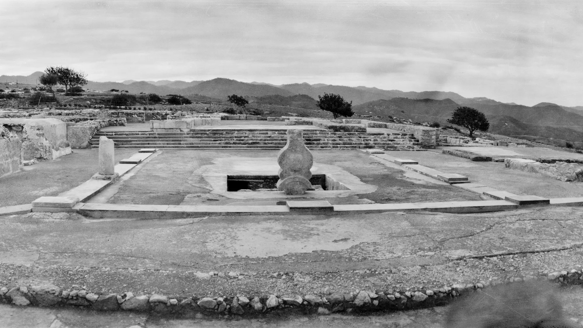
Vouni stands on a hilltop above Morphou Bay, about 4 to 5 km from Soloi. The Swedish Cyprus Expedition dug it in 1928 and 1929; its ancient name is unknown [5]. It was built around 500 BC and burned in the early 4th century, and a hoard of coins and silver and gold jewellery hidden under a staircase lay there until the excavators found it [5]. The plan centres on an open court 17.80 by 16.75 m, ringed on three sides by small rooms. On the fourth, south side a broad staircase of seven steps rises to a tripartite suite: three large rooms in a row, flanked by three smaller rooms on each side. The side walls of the central hall are thicker than the rest, which shows it stood taller than its neighbours [5]. There was no well on the hill. Rain ran off the roofs through gutters and pipes into rock-cut cisterns lined with lime cement, the first a basin in the middle of the court about 7 by 3 m and 8 m deep [5; 1]. Storerooms lined a second court, and there were rooms for cold washing and a hot bath whose sweating room sat over small furnaces [1; 6].
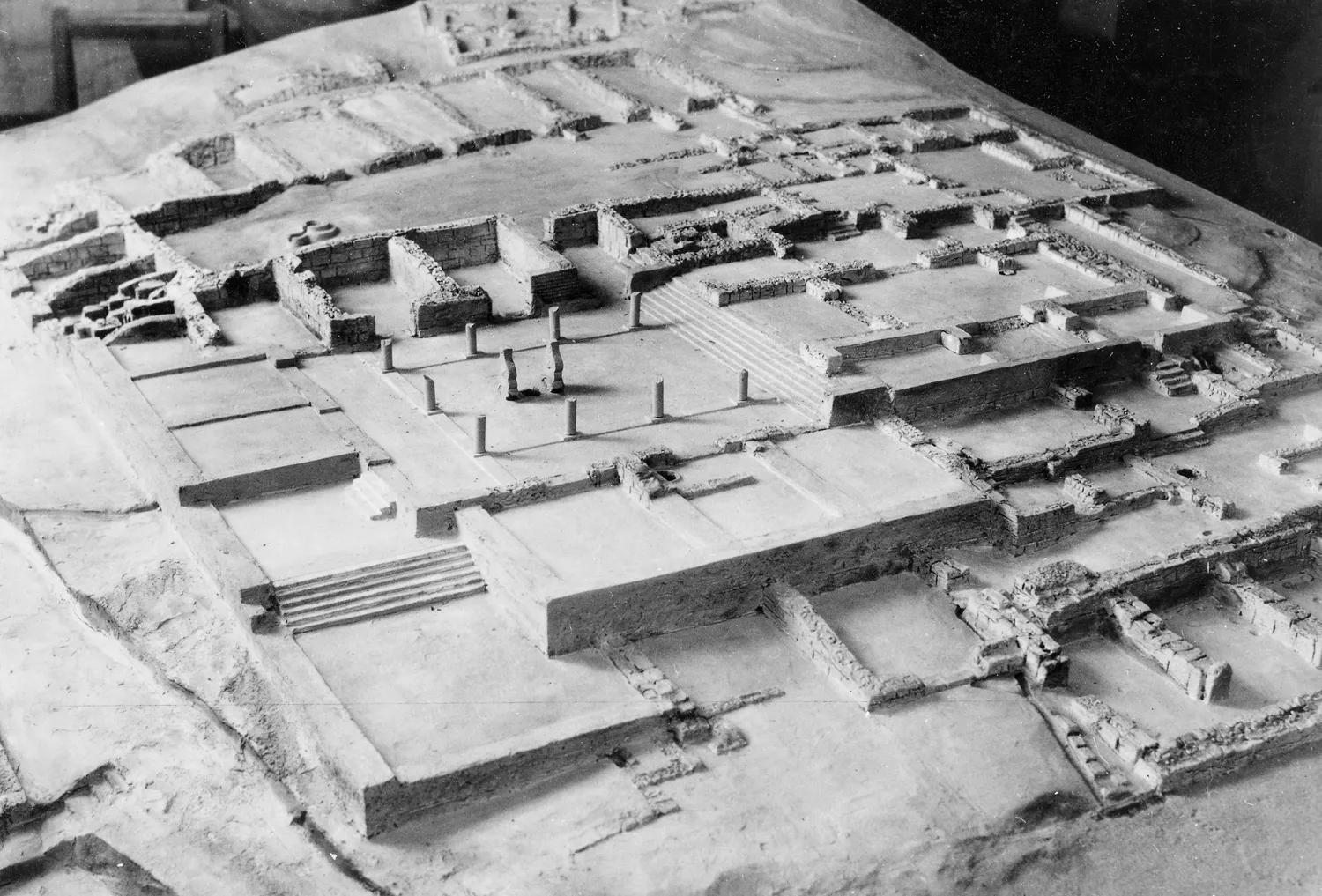
Around 450 to 440 BC the palace was remodelled. A ramp and staircase at the north-west corner became the main entrance, a bottle-shaped cistern was cut 23 m down into the bedrock, and new staircases led to an upper storey whose walls, the excavators noticed, were built in mudbrick of a different colour [5]. A peristyle (a colonnade around a court) of nine columns stood on three sides of the court, carrying a capital carved with the face of the Egyptian goddess Hathor [1; 5]. Gjerstad gave the peristyle to the first palace; Pontus Hellström, re-reading the excavation records, notes that the one surviving capital dates to the remodelling and concludes that the first palace had no colonnade at all [5].
The same staircase has been read two ways. For Gjerstad the palace was entered from the south through the reception suite, and "from the entrance one descends to the central court by a staircase of seven steps" [1]. When a cross-wall later closed the south end of the central hall, he saw a Greek megaron (the long porch-fronted hall of Mycenaean palaces and Greek temples) and a story to match: a pro-Persian king had built Vouni and a pro-Greek dynasty had remodelled it after 449 BC [5]. Hellström reads the plan from the court: visitors came in from the north, and the staircase led up to the halls, which a screen wall hid from the south. Read that way, with Inge Nielsen and others, Vouni is a Near Eastern court palace from the start, its closest parallel the Persian-period "Residency" at Lachish; the megaron and the ethnic story are now rejected [5]. Who lived there is still open: kings of Marion, kings of Soloi, or, as Hellström suggests, a Persian garrison [5]. It remains, in his words, "our consolation for the loss of most other Cypriot palaces" [5].
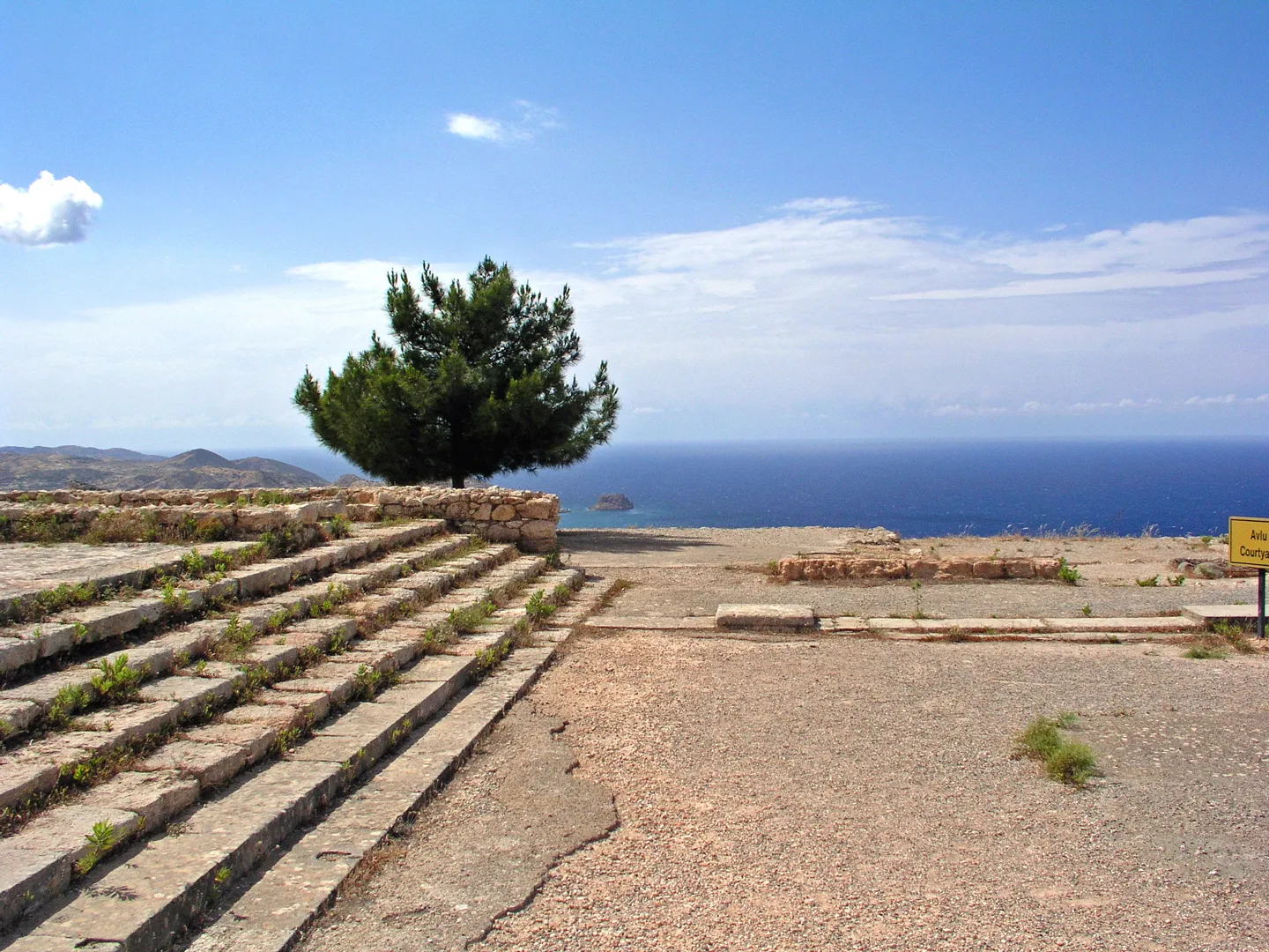
The other palaces are halves. At Amathus a palace stood on a terrace halfway up the acropolis, below the sanctuary of Aphrodite. It was first built in the second half of the 9th century or the early 8th, rebuilt around 500 BC after the city was besieged in the Ionian Revolt, and abandoned in the wars that followed the end of the kingdom around 310 BC. What has been excavated is the storage wing, with dozens of emplacements for big pithoi (storage jars), and a small cult room; the residential rooms have not been found [6]. Fragments of inscribed tablets and seal impressions point to the administration of produce [9]. A great limestone stele carved with the head of Hathor, originally about 170 cm tall and dated around 480 BC, was found below the palace; Hermary thinks it had no structural role and may have flanked the palace entrance [9].
At Idalion the American excavators found a building on the West Terrace that "in its heyday ... must have resembled that of Vouni". From 1991 Maria Hadjicosti's excavations showed that after Kition annexed Idalion in the mid-5th century BC, its Phoenician kings turned part of the fortified palace into a storehouse of pithoi, accounted for on hundreds of inscribed potsherds (ostraca), almost all in Phoenician [6]. As far as we know no complete plan of it has yet been published. At Palaepaphos a building put up around 500 BC against a stretch of the city's rampart on the Hadjiabdoulla plateau, with ashlar lower walls, entered the literature as the "Persian Building", and Franz Georg Maier concluded that a Paphian king had built it on Achaemenid models [6]. Iacovou's excavations on the same plateau have since found a second building of about the same date, a storage and processing complex with drains, millstones and hearths, and she reads the plateau as the kingdom's administrative citadel for the next two centuries [10]. At Marion a Princeton team found an Archaic building better built than anything else on the site, around an inner court of about 10 by 15 m, and cautiously called it a palace; at Soloi a large building on the acropolis slope, located in 1973, was left when work stopped in 1974 [6].
Volutes and Hathor heads: the "Cypriot" capitals
The volute capital, often called Proto-Aeolic, has two spirals curling outward from a central triangle, a stylised palm or sacred tree that came to Cyprus from the Levant and was taken up in the Cypro-Archaic II period, c. 625 to 480 BC; Cypriot carvers added palmettes and lotus flowers above it [13; 14, p. 98; 15]. A related group, the Hathor capitals, sets the face of the Egyptian goddess under a small shrine; these come from Kition, Palaepaphos and Amathus and date from the end of the 6th century into the first half of the 5th [14, p. 98]. Vouni's peristyle capital belongs here [1].
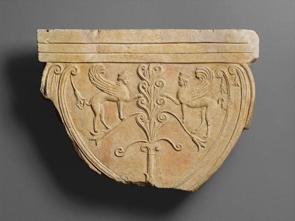
A capital in a museum is not proof of a column. Volute capitals are "not very numerous" in Cyprus, and "most appear to have been finials of stelae", the carved tops of free-standing stone slabs set up as grave markers or offerings [13]. A large example from Idalion in the Cyprus Museum is 106 cm wide and 89 cm high but only 10 cm thick; it may have faced a pilaster (a flat pier set against a wall), and many others crowned votive monuments [15]. The capital from the cemetery of Golgoi beside this paragraph is carved on one face only. The best-preserved architectural examples are in tombs: the royal tombs of Tamassos have carved pilasters with volute capitals and doorways cut to imitate wooden frames (Lesson 10) [13].
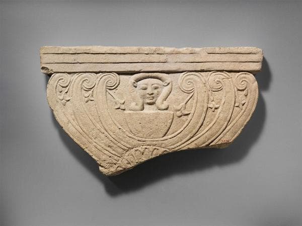
So check two things before restoring a colonnade: how thick the stone is, and how many faces are carved. The Hathor finial beside this paragraph, also from Golgoi, is 6.4 cm thick. A slab that thin, carved on one side, crowned a stele or decorated a wall.
Kition: a Phoenician town and its war harbour
Kition, under modern Larnaca, was the chief Phoenician kingdom on the island. Its settlers, probably from Tyre, rebuilt the great Bronze Age temple on its old ashlar foundations, conventionally around 850 BC (Lesson 9) [12]. In the 5th and 4th centuries BC its kings took Idalion [6] and kept a war fleet, and a fleet needs housing.
The geographer Strabo called Kition's port a closed harbour, and 18th-century maps of Larnaca showed a small basin near the mound of Bamboula. In 1987 and 1988 the French mission found slipways there running down into the filled-in basin [11, p. 14]. A massive east to west terrace wall, buttressed on both faces, held up the court of a sanctuary almost 3 m above the sheds on its south side and served as the back wall of the sheds on its north. The shipsheds were long parallel halls set at right angles to the wall, each 6 m wide and cleared for 30 m without reaching their end; seven had been cleared by 1997. Each covered a slipway 1.8 m wide that sloped down to the water. The complex was built at the end of the 5th century BC and reworked in the 4th; its excavators took the seven bays for one end of a larger installation, housing part of a fleet that served the Persian king [11, pp. 14-15].
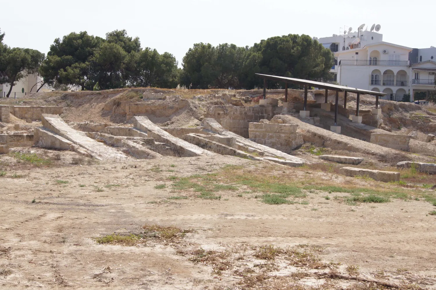
The sheds were roofed with terracotta tiles, many fragments of which were found, laid on timber beams that rested on rows of low walls lined up with the buttresses of the terrace [11, p. 14]. On an excavation plan a vanished roof shows up as rows of stone stubs at regular intervals across a floor, with broken tiles in the fill. At Kition the building under that roof was made for ships.
Quiz
Check yourself
Question
Why can we draw almost no street of an Iron Age capital in Cyprus?
Question
On his clay prism of 673/2 BC, how many kings of Cyprus did the Assyrian king Esarhaddon list by name and seat?
Question
You find an ashlar wall at Vouni. What would you expect behind the dressed blocks?
Question
How well do we know each of these?
Tap a statement, then the bin it belongs in
To sort (5)
Question
Put the history of the Vouni palace in order, earliest first.
Tap an item, then tap its place. Or use the arrows
Question
By Hermary's test, what makes a large Iron Age building a palace?
Question
A volute capital from Idalion is 106 cm wide and 89 cm high, but only 10 cm thick. What did it most likely do?
Question
On an excavation plan of the Kition shipsheds, what shows that the sheds were once roofed?
What to look for
- At the site of a city-kingdom, ask which period the visible walls belong to. At Salamis, Kourion, Soloi and Amathus most of what stands is Hellenistic, Roman or later; the Iron Age town lies underneath.
- Iron Age walls are a stone socle carrying mudbrick. Rubble is everywhere; ashlar, usually a skin of dressed blocks over a rubble core, is kept for palaces, temples and city walls.
- On a palace plan, look for a court with rooms on three or four sides, a tripartite hall reached by steps, long storerooms with pithos emplacements, and cisterns fed from flat roofs.
- A stair, or a change in the brick, is the evidence for an upper storey; the storey itself is inferred. At Idalion, earth-floored stalls on the ground floor point to living rooms above.
- Many volute and Hathor capitals in museums crowned stelae. Check a capital's thickness and whether it is carved on one face or all round before restoring a column under it.
- Fired roof tiles in Iron Age debris are rare and late, from 5th- and 4th-century buildings such as the Kition shipsheds; earlier roofs were flat, of earth and lime on timber. Rows of low walls across a floor may mark where roof beams rested.
Go deeper
The site pages for Idalion, Kition, Amathus, Palaepaphos, Salamis and Tamassos give the history of each kingdom; the architecture overview sets the Iron Age in the long sequence, and the period pages for the Cypro-Geometric, Cypro-Archaic and Cypro-Classical cover the politics. For the expedition that dug Vouni, read the Swedish Cyprus Expedition and its legacy; for the digs at Idalion, the history of Idalion's expeditions; for Amathus, the ancient city of Amathus.
References
- 1.Gjerstad, E. (1948). The Swedish Cyprus Expedition, Vol. IV, Part 2: The Cypro-Geometric, Cypro-Archaic and Cypro-Classical Periods. Stockholm: The Swedish Cyprus Expedition.
- 2.Iacovou, M. (2014). Cyprus during the Iron Age through the Persian period: From the 11th century BC to the abolition of the city-kingdoms (c. 300 BC). In M. L. Steiner & A. E. Killebrew (Eds.), The Oxford Handbook of the Archaeology of the Levant: c. 8000–332 BCE (pp. 795–824). Oxford: Oxford University Press.
- 3.Iacovou, M. (2008). Cultural and political configurations in Iron Age Cyprus: The sequel to a protohistoric episode. American Journal of Archaeology, 112(4), 625-657.
- 4.Karageorghis, V. (1969). Salamis in Cyprus: Homeric, Hellenistic and Roman. London: Thames and Hudson.
- 5.Hellström, P. (2009). The Palace of Vouni Revisited. In Medelhavsmuseet: Focus on the Mediterranean 4 (Papers from the International Seminar: A Cyprus Day in the Medelhavsmuseet), pp. 28–42. Stockholm.
- 6.Hermary, A. (2013). Building Power: Palaces and the Built Environment in Cyprus in the Archaic and Classical Periods. Bulletin of the American Schools of Oriental Research, 370, 83–101.
- 7.Gaber, P., & Dever, W. G. (1996). Idalion, Cyprus: Conquest and Continuity. In W. G. Dever (Ed.), Preliminary Excavation Reports: Sardis, Idalion, and Tell el-Handaquq North (Annual of the American Schools of Oriental Research 53, pp. 85–113). Cambridge, MA: American Schools of Oriental Research.
- 8.Gaber, P. (2008). The History of History: Excavations at Idalion and the Changing History of a City-Kingdom. Near Eastern Archaeology, 71(1/2), 52–63.
- 9.Hermary, A. (2015). Amathus, Capital of the Kingdom and City-State. In A. Nicolaou-Konnari & C. Schabel (Eds.), Lemesos: A History of Limassol in Cyprus from Antiquity to the Ottoman Conquest (pp. 1–48). Newcastle upon Tyne: Cambridge Scholars Publishing.
- 10.Iacovou, M. (2019). Palaepaphos: Unlocking the Landscape Context of the Sanctuary of the Cypriot Goddess. Open Archaeology, 5(1).
- 11.Yon, M., & Childs, W. A. P. (1997). Kition in the Tenth to Fourth Centuries B.C. Bulletin of the American Schools of Oriental Research, 308, 9–17.
- 12.Karageorghis, V. (1976). View from the Bronze Age: Mycenaean and Phoenician Discoveries at Kition. New York: Dutton.
- 13.Buchholz, H.-G., Matthäus, H., & Walcher, K. (2002). The royal tombs of Tamassos: State of research and perspectives. Cahiers du Centre d'Études Chypriotes, 32. https://doi.org/10.3406/cchyp.2002.1415
- 14.Shefton, B. B. (1989). The Paradise Flower, a 'Court Style' Phoenician Ornament: its history in Cyprus and the Central and Western Mediterranean. In V. Tatton-Brown (Ed.), Cyprus and the East Mediterranean in the Iron Age (pp. 97–117). London: British Museum Publications.
- 15.Tatton-Brown, V. (Ed.). (1979). Cyprus BC: 7000 Years of History. London: British Museum Publications.