
Contents
In the Iron Age Cyprus was divided among about ten kingdoms, each ruled from a capital town: Salamis, Kition, Amathus, Paphos, Kourion, Idalion, Tamassos, Marion, Soli, Lapethos and others at various times. Most of those towns stayed inhabited for a thousand years and more, through the Cypro-Geometric, Cypro-Archaic and Cypro-Classical periods and on into Hellenistic and Roman times, so their Iron Age streets and houses lie under, or were cleared away by, the cities that followed. What has been recovered is a short list: one palace known in full at Vouni, parts of palaces at Amathus, Idalion, Palaepaphos and Marion, one complete house plan at Idalion, and the war harbour of Kition. Around them sit a few building elements, above all the carved limestone capitals that Cypriot masons put on stelae, doorways and columns. This entry covers the towns, the palaces and the houses; the walls are treated under fortifications, and the same ground is walked in the course lesson on cities of the kings.
The cities of the kingdoms
Why the towns are hard to see
The main reason is that the towns never died. Maria Iacovou has described how "archaeologists in Cyprus have come to lament the absence of destruction levels or abandonment episodes that could have preserved the basic internal structure of settlements in the Cypro-Geometric and Cypro-Archaic periods" [1]. A town that is sacked and left empty preserves its plan; a town that is rebuilt on the same spot for centuries keeps only scraps of its earlier phases. Excavators have isolated fifth- and fourth-century levels in a few places (Kition, Idalion, Amathus and Palaepaphos), but elsewhere even the Classical strata have very poor visibility. At Salamis and Kourion the visible ruins are the gymnasia, theatres and baths of late antiquity, whose builders "have eradicated the secular and sacred environment" of the earlier town, and the few earlier remains turned up by chance while those monuments were being dug [1]. The later buildings belong to theatres, baths and public buildings.
Antoine Hermary put the consequence plainly: "A detailed study of the topography of Cypriot cities in the time of the Iron Age kingdoms is not possible based on our present state of knowledge" [2, p. 83]. The best points of reference, in his view, are the sites where both the main sanctuary and the royal residence are known, which means Amathus, Vouni and Idalion; only Amathus lets the relation between sanctuary and palace be followed from the late Cypro-Geometric period down to Alexander [2, p. 83]. Salamis certainly had a palace, but it is known only from literary sources [3, p. 37].
The early Iron Age is even thinner. Einar Gjerstad, who synthesised the Swedish excavations of 1927 to 1931, could point for the Cypro-Geometric period only to fragments of a rectangular or trapezoid room on the acropolis of Kition, of mudbrick on rubble foundations, which "may be a specimen of domestic architecture", and to house walls at Kourion-Bamboula whose date the excavators themselves disputed (J. F. Daniel placed them in Late Cypriot III, Erik Sjöqvist in Cypro-Geometric I) [4]. For the Cypro-Archaic and Cypro-Classical periods he wrote that "the only remains of domestic architecture from the periods in question are those of the palace at Vouni" [4]. Later work has added to that list, as the sections below show, but the towns between the Late Bronze Age and the Hellenistic period remain poorly known (compare Late Bronze Age towns and Hellenistic and Roman houses).
What a town contained
The pattern that emerges from the better-known sites is an acropolis carrying a palace and a main sanctuary, with a lower town of houses and workshops below and, by the Archaic period, a circuit wall around the whole. At Amathus the palace stood on the acropolis next to the sanctuary of the goddess [2, p. 83]. Idalion had two acropoleis: the western one with the palace, the eastern one (Mouti tou Arvili) with sanctuaries, and between and below them a lower city of houses and industrial buildings [7, p. 89]. Lawrence Stager and Anita Walker, who excavated there for the American expedition, found that "towards the end of the Cypro-Archaic II (about 550–475 BCE) the fortifications on the West Terrace were radically re-organized and the whole city enclosed with a fortification wall" [5]. The enclosed area was about 40 hectares, and Lawrence Stager estimated a population of 8,000 to 10,000 [5]. Sanctuaries, in town and outside it, are covered under Iron Age sanctuaries.
Idalion also shows how a town can move. The river shifted over the centuries and the settlement followed it north, so that instead of a tell built up in layers there is "a kind of horizontal progression of occupation", ending in the medieval and modern village whose name was shortened to Dhali [7, p. 89].
Kition's war harbour
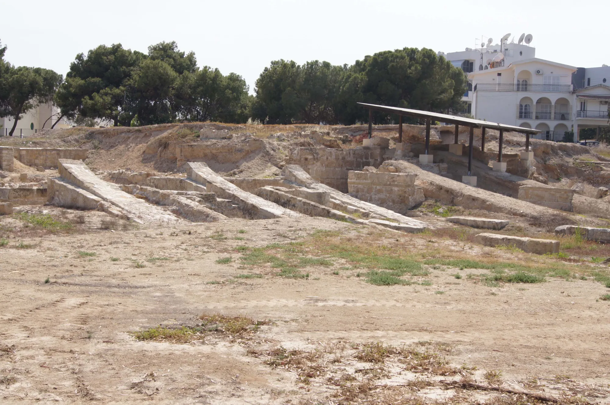
Kition has the one excavated naval base of an Iron Age Cypriot city. Strabo is the only ancient author who mentions it, as a closed port. Eighteenth-century maps by Pococke (1738), Niebuhr (1766) and Mariti still showed a small basin north of the Bamboula hill, and the marshes there were filled in by the British in 1860 [6, pp. 13–14]. The French mission under Marguerite Yon found the marine buildings in 1987 and confirmed them in 1988: slipways running down into the filled basin, which placed the closed port immediately north of the sanctuary of Astarte and Melqart at Bamboula [6, p. 14].
The sheds were built at the end of the fifth century BC and reworked extensively in the fourth. About 1,500 square metres were cleared, in a trench that floods because the water table is only 1.5 to 2 metres above sea level. An east to west terrace wall, buttressed on both faces, holds up the sanctuary court almost 3 metres higher and forms the back wall of the sheds. Each shed was 6 metres wide and was cleared for 30 metres of its length; the slipways were 1.8 metres wide; seven sheds were exposed. The roofs were of tiles, of which many fragments were found, carried on wooden beams that rested on lines of small walls set on the axes of the buttresses [6, p. 14]. In the earliest state only the upper 10.5 metres of each ramp were built in stone and mortar, the rest running on the natural beach slope; longitudinal beams with wooden rollers took the keel, and the bows rested on the built ramps at about 13 degrees [6, p. 15].
The closest comparison is the shipsheds of Piraeus of the same date. A trireme was about 35 to 37 metres long, so the sheds continue beyond the excavated stretch. Yon and William Childs concluded that a closed basin with sheds inside the ramparts belonged to the city's defences, and that "there is space for seven triremes, but this is just the end of a complex that must be larger still to house a fleet that formed an important part of the naval forces of the Great King" [6, p. 15]. The same Classical building programme rebuilt the temple of Astarte and Melqart at Bamboula and gave the city a network of drains [6, p. 13]. Kition was a city with a strong Phoenician element (see Phoenicians and Melqart), and its fleet served Achaemenid Persia.
Palaces
Vouni
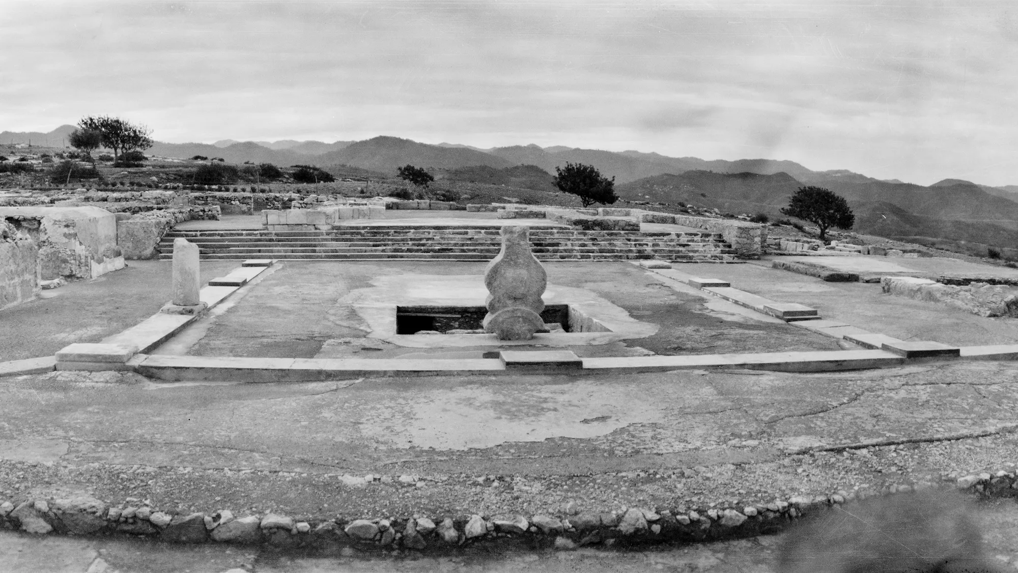
Vouni stands on a hilltop on the north-west coast, near Soli. Its name in antiquity is unknown; an old identification with Aipeia was rejected by Alfred Westholm [3, p. 38]. The Swedish Cyprus Expedition excavated it completely, and Hermary calls it "currently the only example where the entire compound is known" [2, p. 83]. It belongs to the early Classical period: the first palace was put up about 500 BC and the whole complex was in use for little more than a century. The core was an open courtyard 17.80 by 16.75 metres, with small rooms on its east, north and west sides. On the south a broad monumental staircase of seven wide steps "led up to the main reception halls". These were laid out in three parts, three large rooms in the middle and three smaller ones on either side, and the thick side walls show that the central hall rose higher than the rest [3, p. 31]. In the court was a basin cistern about 7 by 3 metres and 8 metres deep, fed by underground drains. There were two bathrooms, a kitchen in a separate building, and the main sanctuary lay outside the palace to the north; a sanctuary of Athena occupied the highest point of the hill. Around 475 BC five storerooms were added on the north-east, together with a heated room for a hot bath, warmed from below [3, p. 31].
Vouni rebuilt and destroyed
Around 450 or 440 BC the palace was given a new monumental entrance at the north-west, a ramp and broad staircase, with an angled approach into the court. The old cistern was replaced by a bottle-shaped one "dug down 23 m into the bedrock" [3, pp. 31–32]. New staircases in the south-east and south-west wings, and mudbrick of a different colour in the upper walls, show that a second storey was added, and a second court to the east was built with storerooms and a rebuilt kitchen [3, p. 34].
The palace was destroyed by fire in the early fourth century and never rebuilt [3, p. 37]. Its walls, floors and roofs are described below under building methods.
The Vouni debate: royal palace or Persian fortress
Gjerstad, who published the excavation in 1937, read Vouni as a royal palace. In the excavators' reconstruction the first palace was entered from the south or south-west, the great staircase led down into the court, and a three-sided peristyle of nine columns surrounded it. Gjerstad dated the destruction to about 380 BC on the strength of coins of a king Demonikos in a hoard found in the palace, whom he took to be a king of Kition [3, pp. 31, 34, 35, 37].
Hellström, returning to the building in 2009 and following Nielsen's study of the plan, revised each of these points. He holds that Vouni I was entered from the north and that the staircase led up from the court to the reception rooms; Nielsen compared the arrangement with the Residency at Lachish, a palace of the Persian period built under Achaemenid influence [3, pp. 31, 35]. Vouni I "had no peristyle": the only capital from the site dates to about 450 to 440 BC [3, p. 34]. The Demonikos coins belong to Demonikos II of Lapethos, which removes the support for the 380 date, and Hellström sets out four possible causes for the early fourth-century destruction: an attack on Soli by Evagoras of Salamis around 391, Evagoras's war with the Persians in 390 to 388, later fighting in the 380s, or an accidental fire [3, p. 37]. Because the palace stood for only about a hundred years and was never rebuilt, he wrote, "this suits the hypothesis that it was an Achaemenid fortress very well", and he added that the residence of a Persian garrison commander may still have followed local building traditions [3, p. 37].
Neither side has settled the question. Hermary, writing in 2013, included Vouni with Amathus and Idalion among the sites that pair a sanctuary with a royal residence, while noting that its status "gives rise to debates" [2, p. 83]. Hellström himself treated it as "the only completely preserved palace in Cyprus from the Archaic and Classical periods" [3, p. 38], whoever lived in it.
Amathus
At Amathus the palace occupied part of the acropolis, and the French excavations there give the only sequence that runs through the whole life of a kingdom. Following Alpe, Petit and Velho (2007), Hermary dates the first phase to the second half of the ninth century BC, or at the latest the early eighth (Hellström, writing earlier, had given about 700 BC [3, p. 38]). In a second, Archaic phase the building was modified and the area was already used to store agricultural produce. The most visible remains belong to a third phase of about 500 BC, which Hermary connects with the siege of Amathus during the Ionian Revolt [2, p. 88]; this was the siege after which, in Herodotus's account, the head of Onesilos of Salamis was hung on the city wall (Herodotus 5.104–114) [2, p. 89]. The contents of the palace seem to have been dumped at the foot of the acropolis after that destruction: fragments of one early seventh-century krater were found both in the palace and in a deposit by the northern rampart [2, p. 90].
In the fifth and fourth centuries storage grew, with "dozens of loci for the placement of large clay pithoi". After the kingdom was abolished around 310 BC, the war between Ptolemy and Antigonos and Demetrios brought abandonment and destruction [2, p. 89]. The excavated part is mostly storerooms, with a small cult place to the north [2, p. 89]. A large Hathor capital of the Vouni type, of about 480 BC, found reused in a later wall, may come from the palace [3, p. 38]. The site is described further in the ancient city of Amathus.
Idalion
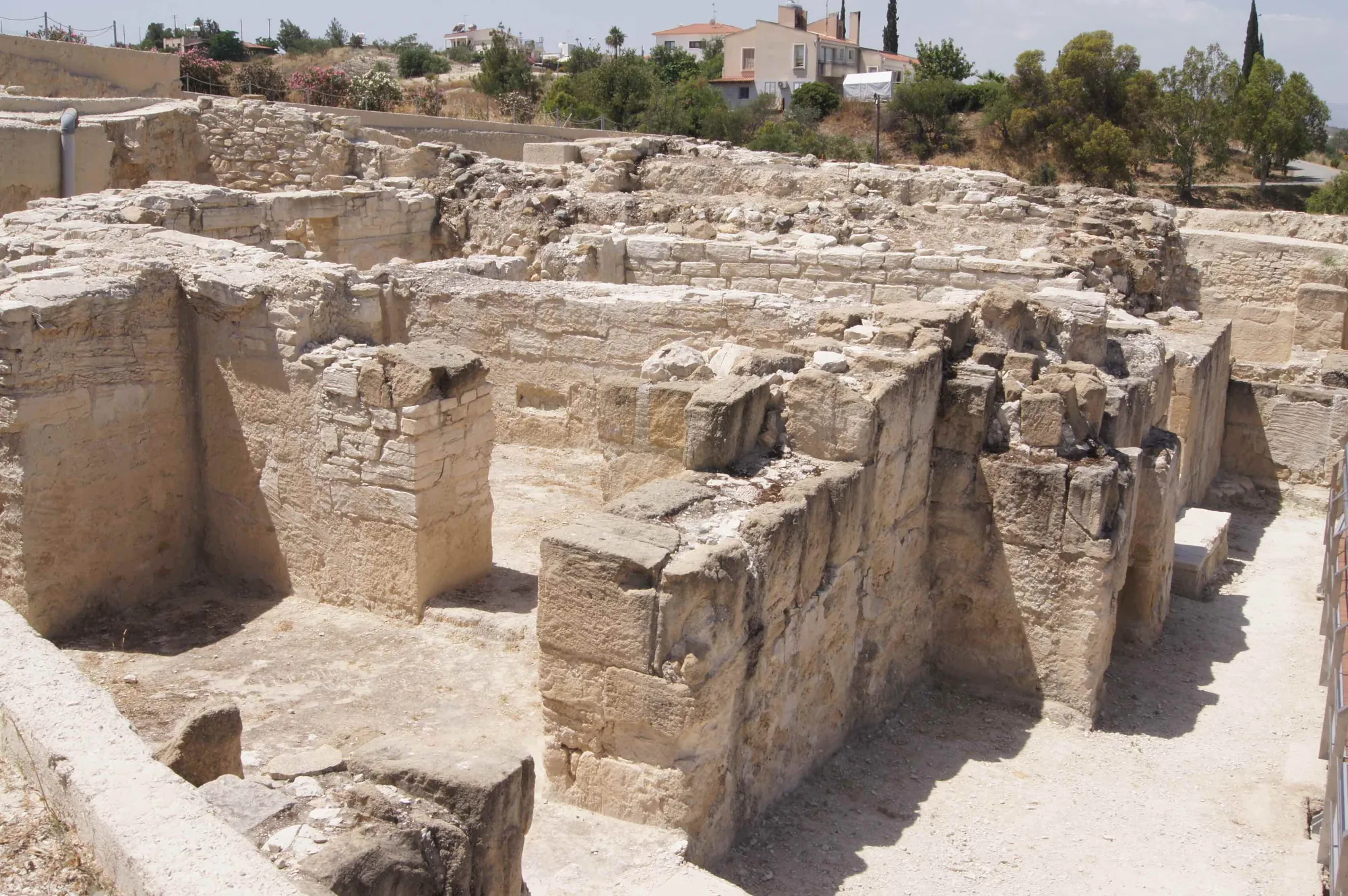
Two expeditions have worked on the western terrace of Idalion and given two accounts of the same ground. The American team under Stager and Walker described their Phase 5, from the end of the sixth to the middle of the fifth century, as "a single palatial complex", and wrote that "in its heyday the Palace of Idalion must have resembled that of Vouni" [2, pp. 90–91]. The palace and much of the monumental architecture inside the walls were destroyed when Idalion was conquered around 450 BC, leaving 1.5 to 2 metres of destruction debris; lighter structures followed, and the area was abandoned around 300 BC [7, pp. 85, 89].
From 1991 Maria Hadjicosti of the Department of Antiquities excavated a large administrative and industrial building on the Ampileri part of the terrace. It dates to the fourth century, after Idalion had been annexed by Kition, and in Hermary's words was "almost certainly erected at the location of the palace of the kings of Idalion, whose reign ended around the middle of the fifth century B.C." The Kitian kings converted part of an earlier fortified building into a storehouse, with pithoi and hundreds of ostraca, almost all written in Phoenician. Hermary regards the identification of the first building as the palace of the local kings as certain [2, p. 91]. The work of both teams is told in the history of Idalion's expeditions.
Palaepaphos and Marion
At Palaepaphos the excavations directed by Franz Georg Maier uncovered a building against the rampart on the Hadji Abdullah plateau, built at the end of the Archaic or start of the Classical period, with ashlar lower walls and features close enough to Achaemenid architecture that it was called the "Perserbau", the Persian building. Maier judged that "it still appears more likely that one of the Paphian kings built this residence: as a Persian vassal, he took the palaces of the Achaemenid overlords as a model". It was partly destroyed at the end of the fifth century, rebuilt more modestly and abandoned at the end of the fourth [2, p. 92]. About 100 metres away, towards the sanctuary of Aphrodite, a residence at Evreti had a small peristyle court and a column base of Achaemenid type and was abandoned by about 300 BC; Maier later became cautious about linking it with the Hadji Abdullah building [2, p. 92], and its palatial character, in his words as quoted by Hellström, is "yet to be demonstrated" [3, p. 38].
At Marion, the Princeton expedition found on the Peristeries plateau an Archaic building of great size whose quality of construction William Childs described as "unsurpassed in the entire site of Marion". It held imports from East Greece, Corinth and Attica and had two courtyards, the inner one about 10 by 15 metres. Nassos Papalexandrou called it "a reasonable working assumption" that this was the palace, "or at least a significant center of power" [2, p. 92]. At Soli, Gjerstad suggested that a large building on the slope of the acropolis was a royal palace [2, p. 92].
What made a palace
Hellström reckoned that "we can safely expect that each city-kingdom had a royal palace", and listed more or less certain remains at Amathus, Paphos, Soli and Idalion [3, p. 37]. The excavated examples share several traits. They sat high, on an acropolis or a terrace inside the walls, and close to a main sanctuary [2, p. 83]. They were organised around courts. A large share of their floor space was storage: the pithos rooms of Amathus, the storehouse at Idalion and the storerooms added at Vouni [2, pp. 89, 91; 3, p. 31]. At Idalion the stores came with written records, the Phoenician ostraca [2, p. 91]. Their walls were mudbrick above stone or ashlar lower courses, and in the fifth century several show Achaemenid touches, such as the column bases at Evreti and the plan at Hadji Abdullah [2, p. 92]. Their lives were also tied to political events: Amathus rebuilt after the Ionian Revolt, Idalion's palace destroyed in the Kitian conquest, Vouni burnt in the wars of the early fourth century [2, pp. 88, 91; 3, p. 37]. For the economy of the kingdoms, see the copper kingdoms of ancient Cyprus.
Houses and building methods
The Idalion house
The one complete Iron Age house plan from Cyprus comes from the lower city of Idalion. Domestic architecture there lies only about "10 cm below the modern surface", and between 1972 and 1977 the American expedition "uncovered the complete floor plan of one house, together with the street running alongside it and fragments of its neighbors to the south, east, and north" [7, p. 89]. The houses were "constructed of mudbrick over field stone socles, with beams in the ceilings". The excavators thought it "quite likely that they consisted of more than one story, as there is evidence of animal quarters on the uneven earth floors of the ground floor rooms", which suggests the family lived upstairs. In one house a basement room dug into virgin soil held an olive press, with the living quarters above it. The lower levels of the quarter stayed in use through the Cypro-Archaic and Cypro-Classical periods, about 675 to 300 BC [7, p. 89]. The excavators compared these houses with a type "known from medieval towns like Kakopetria and indeed from modern Cypriot villages" [7, p. 89]; the comparison is the excavators' own analogy of form.
Walls, floors and roofs
What is known of construction comes mostly from Vouni and from Gjerstad's synthesis. Walls were of stone and sun-dried brick, with stone usually confined to the foundations; masonry was rubble, ashlar or a mixture of the two, and "the ashlar walls are never solid": the dressed blocks formed a facing around a fill of small stones, gravel and earth, sometimes with gypsum and lime-concrete [4]. (For the stone itself and the earlier ashlar tradition, see stone, ashlar masonry and building materials and techniques.) At Vouni the walls were mudbrick on a stone base and probably stuccoed; floors were of lime cement finished with white plaster; thresholds, jambs and lintels were of wood [3, p. 31].
Roofs were flat. Gjerstad described them as "flat or slightly sloping and ... built of a dunnage of straw resting on the wooden beams and tightened and covered with clay and lime" [4], and at Vouni most roofs were probably "flat and slightly sloping for the collection of rainwater", which drained into the cisterns; the taller reception hall may have had a pitched roof [3, p. 31]. No terracotta roof tiles were found at Vouni [3, p. 38 n. 15]. Tiles do appear on the Kition shipsheds at the end of the fifth century [6, p. 14]. Columns at Vouni were cylindrical or elliptical, standing on low rectangular slab bases, and one staircase rose in three flights to the upper storey [4].
Cypriot capitals
Volute capitals
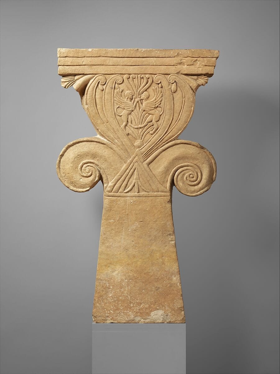
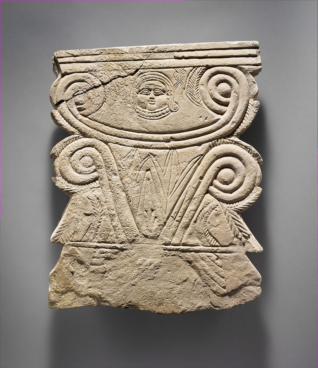
Much of what is known of Iron Age architectural ornament comes from tombs and grave stelae. The most distinctive is the volute capital, often called Proto-Aeolic: two volutes curling out from a triangular base. Its best parallels are in Israel in the early first millennium BC (Jerusalem, Ramat Rahel, Hazor, Megiddo), where such capitals topped the pillars of city and palace gates. No large stone examples are known from Phoenicia proper, but the type seems to have started there, to judge from ivories found at Samaria and at Salamis. "In Cyprus the type seems to have been adopted during Cypro-Archaic II (c. 625–480 BC). Besides the Tamassos tombs, Proto-Aeolic capitals are known from several sites on the island, although they are not very numerous. Most appear to have been finials of stelae" [8].
At Tamassos, pillars with these capitals flank the entrances of Tombs 5 and 12, the only funerary use of the type; the doorways have recessed frames that copy woodwork, the lintel of Tomb 5 imitates wooden beams, and false windows carry balustrades [8]. Ephraim Stern's list of Phoenician and Israelite building features, which includes headers and stretchers, ashlar piers with fieldstone fill, volute, Hathor and papyrus capitals, recessed openings and window balustrades, fits these tombs closely [8]. The Tamassos royal tomb reconstruction rebuilds one of them, and the tombs themselves belong to royal and built tombs and the wider mortuary practices section.
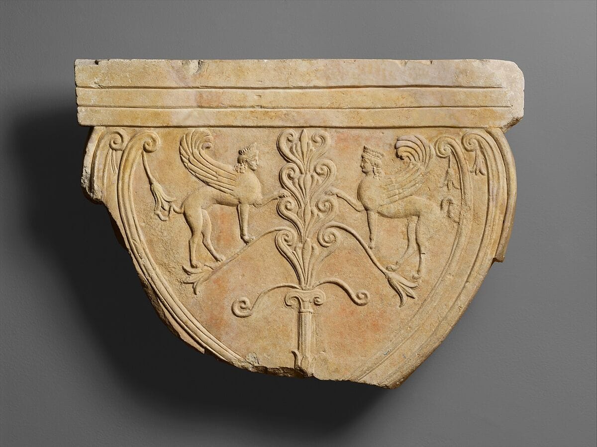
The best-known stelae are in the Metropolitan Museum, from Luigi Palma di Cesnola's collection. A tall limestone shaft there, the stele with a "Cypriot capital" from the necropolis of Golgoi, stands 137.2 cm high and dates to the fifth century BC. The Met notes that shafts with such capitals were carved on Cyprus from the seventh to the fifth century and that most come from Golgoi or Idalion; on this one an Aeolic capital carries two pairs of curved fronds and a tree of life flanked by sphinxes (Met 74.51.2493). A fragmentary capital of the same scheme, carved on one side only and "of a type known only on Cyprus", shows the sphinxes standing on lotus stems with a paw on the tree (Met 74.51.2497). Both belong to the Cesnola Collection and to the limestone carving tradition described under Archaic limestone sculpture.
Hathor capitals
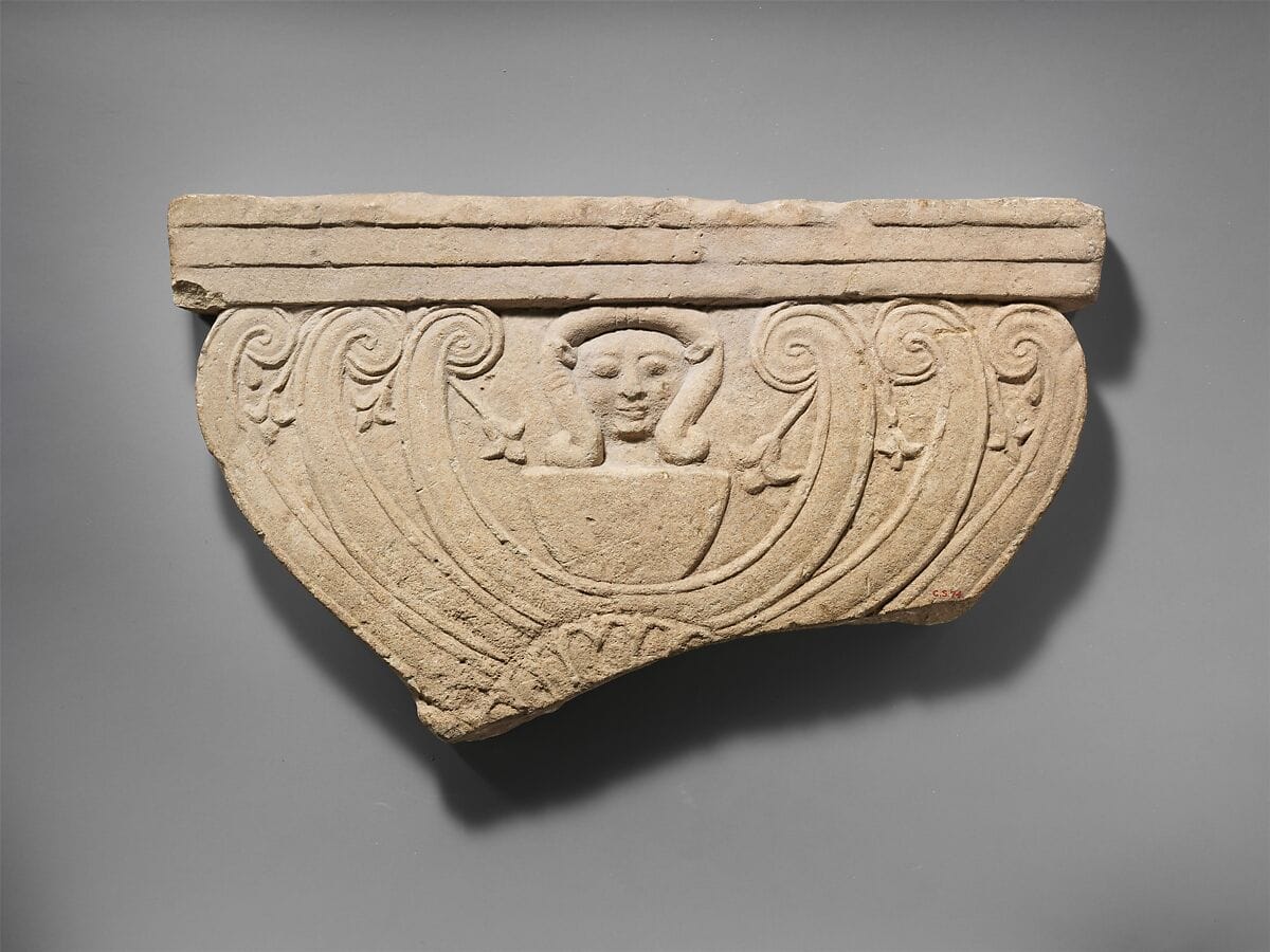
The second Cypriot form takes the head of the Egyptian goddess Hathor, with her broad face and cow's ears, and sets it on a block above the column. Vouni produced one: "a Cypriote variety of the Hathor capital, with a female head in relief on the two long sides and an uraeus in a niche above it" [4], which Hellström dates to about 450 to 440 BC, the time of the second palace [3, p. 34]. The Amathus example of about 480 BC, found reused in a later wall, is of the same type [3, p. 38].
The same head appears on grave stelae. A stele finial with volutes and the head of Hathor from Golgoi, 78.7 cm wide and dated to the second or third quarter of the sixth century BC, sets the head above a sacred tree between lotus flowers (Met 74.51.2495), and a later stele with volutes and a Hathor head, of the late fifth century, is also in the Met.
Open questions
The main questions are still open. Vouni may have housed a local king or a Persian commander, and the cause of its burning is unknown. The Hadji Abdullah building at Palaepaphos is read either as Persian or as a Paphian king's copy of Persian models, and Evreti's status is unproven. The Marion building is a palace only as a working assumption. And the palace of Salamis is known only from texts [3, p. 37].
Objects on this page
References
- 1.Iacovou, M. (2014). Cyprus during the Iron Age II period (c. 750–312 BC). In M. L. Steiner & A. E. Killebrew (Eds.), The Oxford Handbook of the Archaeology of the Levant c. 8000–332 BCE (ch. 53). Oxford: Oxford University Press.
- 2.Hermary, A. (2013). Building power: Palaces and the built environment in Cyprus in the Archaic and Classical periods. Bulletin of the American Schools of Oriental Research, 370, 83–101. https://www.jstor.org/stable/10.5615/bullamerschoorie.370.0083
- 3.Hellström, P. (2009). The palace of Vouni revisited. In Medelhavsmuseet: Focus on the Mediterranean 4 (pp. 28–42). Stockholm: Medelhavsmuseet.
- 4.Gjerstad, E. (1948). The Swedish Cyprus Expedition, Vol. IV, Part 2: The Cypro-Geometric, Cypro-Archaic and Cypro-Classical Periods. Stockholm: The Swedish Cyprus Expedition.
- 5.Gaber, P. (2008). Excavations at Idalion and the changing history of a city-kingdom. Near Eastern Archaeology, 71(1–2), 52–63.
- 6.Yon, M., & Childs, W. A. P. (1997). Kition in the tenth to fourth centuries B.C. Bulletin of the American Schools of Oriental Research, 308, 9–17. https://www.jstor.org/stable/1357405
- 7.Gaber, P., & Dever, W. G. (1996). Idalion, Cyprus: Conquest and continuity. In W. G. Dever (Ed.), Preliminary Excavation Reports: Sardis, Idalion, and Tell el-Handaquq North (Annual of the American Schools of Oriental Research 53, pp. 85–113). American Schools of Oriental Research.
- 8.Buchholz, H.-G., Matthäus, H., & Walcher, K. (2002). The royal tombs of Tamassos: State of research and perspectives. Cahiers du Centre d'Études Chypriotes, 32. https://www.persee.fr/doc/cchyp_0761-8271_2002_num_32_1_1415