
Contents
Houses of the Hellenistic and Roman periods on Cyprus are known from two very different kinds of evidence. At Nea Paphos a row of large town houses survives mainly as mosaic floors, because their walls were quarried away for building stone, so the plan has to be read from the edges of the floors. At Kourion a modest house flattened by an earthquake in the later 4th century AD kept its stone footings, fallen mudbrick, roof tiles and nails, so its walls and roofs can be rebuilt with some confidence. Between them the two sites cover the span from the founding of Nea Paphos, between 321 and 312 BC, to the earthquakes of the 4th century AD. Theatres, baths and the agora belong under theatres, baths and public buildings, and the course lesson on houses and towns of Hellenistic and Roman Cyprus gives a shorter, illustrated introduction.
A planned town: Nea Paphos
The grid
Nea Paphos was founded towards the end of the 4th century BC by Nicocles, the last king of Palaepaphos [1, p. 9]; Jolanta Młynarczyk places the foundation between 321 and 312 BC [2]. The walled town covered about 950,000 m² (see fortifications). In the words of Demetrios Michaelides, "right from the beginning, the town was built on an orthogonal plan based on a grid of streets cutting each other at right angles and forming rectangular insulae", and the street system stayed in use "with only minor changes" for the rest of the town's history [1, p. 9]. It was the Ptolemaic capital by the 2nd century BC and the Roman capital after 58 BC [1, p. 10].
Młynarczyk describes the plan as "Hippodameian" or "Milesian", with insulae about 35 m wide and first estimated at 78 to 80 m long, possibly about 105 m, and she notes that "the original grid alignment had been respected down to the end of antiquity" [2]. In the Maloutena and Ktisto quarter the streets run on north-east to south-west axes, while the rest of the town follows the cardinal points. Młynarczyk explains the change as an adjustment to the hill of Fanari. Wiktor Daszewski had proposed insulae of about 30 by 80 m and saw the south-western district as a later enlargement with no need to follow the ground, a view Młynarczyk says "can hardly be shared" [2]. The streets between the house blocks of this quarter were about 5 m wide [3].
A residential quarter
The residential quarter lay west of the harbour [1, p. 9]. South of the agora the excavated houses line up one after another: the House of Dionysos, the House of Orpheus, the 'Hellenistic' House, the Villa of Theseus and the House of Aion [3]. Each overlies something older. At Maloutena and Ktisto the Roman houses sit on Late Hellenistic remains "of a similar nature" [2], and the House of Dionysos was built on the ashlar foundations of an earlier Hellenistic house [4, p. 9].
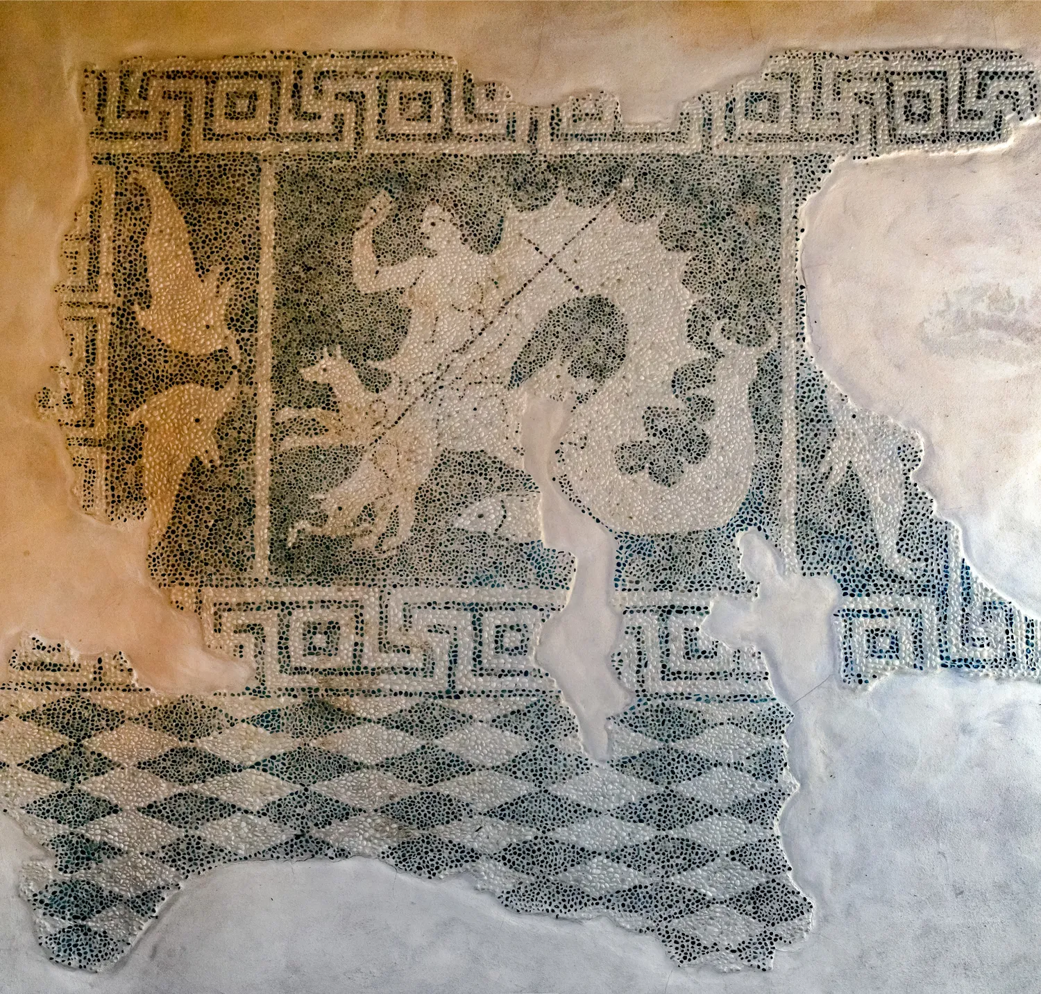
A Hellenistic pebble mosaic of Scylla, from a building under the south-west corner of the later portico, was found beneath the House of Dionysos and has been relaid in Room 1 [1, p. 14]. Under the plainest floor of the house, in Room 13, an amphora 45 cm down held 2,484 silver Ptolemaic tetradrachms of 204 to 88 BC, the largest Ptolemaic hoard found in Cyprus. It belongs to an earlier phase beneath the house [1, p. 33]. Michaelides stresses that the lavish floors above were ordinary for the town: "such rich decoration was not the exception but the norm for Paphos during the mid-Roman period" [1, p. 11].
Courtyard and peristyle houses
The 'Hellenistic' House
The 'Hellenistic' House was named after an early find of an irregular pebble floor thought to be Hellenistic. Later work showed that the house was built in the Roman period, with its last phase in the late 1st and early 2nd century AD [3]. It was excavated by the Polish Archaeological Mission from 1986. The house filled about three-quarters of an east to west insula. It was occupied for "only a handful of decades", destroyed by an earthquake and never rebuilt. The Villa of Theseus was later built over its northern part, and many of its walls were robbed for stone in antiquity [3].
The main court was a Rhodian peristyle, the type Vitruvius describes, in which one portico stands taller than the rest. Here the west portico (Corinthian) and a north pseudo-portico of half-columns on pilasters were almost twice the height of the Doric south and Ionic east porticoes, so each side of the court had its own order. Aleksandra Brzozowska-Jawornicka proposes an upper floor with galleries over the lower porticoes [3]. A second court was a tetrastyle atrium, 10.15 by 9.8 m, with an impluvium about 3 m square, a hydraulic floor and a pipe outlet. Its columns were nearly 4 m high, with a blocked-out pseudo-Ionic capital that is the only one known on Cyprus. Doric frieze blocks have sockets for the beams of an upper-storey ceiling, and the cornice above was carved as a gutter (sima) with outlets, coated in hydraulic mortar, which sent rainwater into the impluvium and tanks. Two staircases led up to a terrace [3]. A limestone cornice with a lion's head from the sanctuary of Apollo Hylates at Kourion, Early Roman and now in the Metropolitan Museum (74.51.2617), is a sima of the same kind from a public building.
The House of Dionysos
The House of Dionysos was found during levelling work at Ktisto in 1962 and excavated by Kyriakos Nicolaou between 1962 and 1965. Its early identification as the proconsul's residence "can now be dismissed", and it has 556 m² of mosaic [1, p. 11]. Christine Kondoleon describes "a quadrangular plan of roughly 56 meters by 30 meters (2,000 sq. m.) with over forty rooms" [4, p. 9]. It falls into three blocks on a north to south axis, each round its own court. The western block held the main entrance, the dining room (triclinium) and service quarters round a small court with a basin; the central block the peristyle, the reception rooms and the richest mosaics; the eastern block the bedrooms near the fishpond, and the latrines [4, p. 9]. "The plan functioned to isolate guests from inhabitants" [4, p. 10].
The house stands on the walls of a Flavian building, itself over earlier structures. Ktisto was later quarried for dressed blocks, and the walls have almost completely disappeared. The edges of the mosaics show where walls stood, but doorways are often impossible to place, and the main entrance is uncertain; an inscription in Room 3 suggests one on the south [1, p. 12]. The floors also sorted the rooms by use. The bedrooms had floors of pebbles set in mortar, and the kitchens and workshops beaten earth [1, p. 13]. Most of the wall paintings went with the robbed walls [1, p. 13].
The date of the house is disputed. Michaelides dates its building to "the very end of the 2nd cent. A.D." and its destruction to the earthquakes of the first half of the 4th century [1, p. 14]. Kondoleon, following John Hayes, points out that an amphora deposit in the east portico contains no types made after AD 200, proposes a destruction in the late 2nd century, perhaps by an earthquake, and notes the absence of 3rd- and 4th-century pottery and coins [4, pp. 8-9].
The Villa of Theseus and the House of Aion
The Polish Mission from Warsaw began work at Maloutena in 1965. The Villa of Theseus was begun, probably in the second half of the 2nd century AD, over Hellenistic and early Roman houses, and lasted to at least the early 7th century, when squatters, lime kilns and ovens took over [1, p. 52]. Its plan of four wings round a large court, with mosaic-floored porticoes on three sides and an unpaved centre, is "inspired by Hellenistic tradition", in Daszewski's words. The villa "grew horizontally rather than vertically, covering several insulae": it measures over 120 m east to west and over 80 m north to south, and a new street was opened along its east façade. An upper storey existed only in parts, reached by stairs in Rooms 21 and 53 [1, p. 52]. The inner court measures 46 by 38 m, and a tetrastyle atrium had a marble-lined impluvium [1, p. 53].
Daszewski suggests that the building was a villa publica, possibly the residence of the governors or proconsuls, on the evidence of its plan and size, its marble statues and revetment, and a rare Latin inscription naming porticoes. He calls it "the largest residential structure of its type found on the island so far" [1, p. 53].
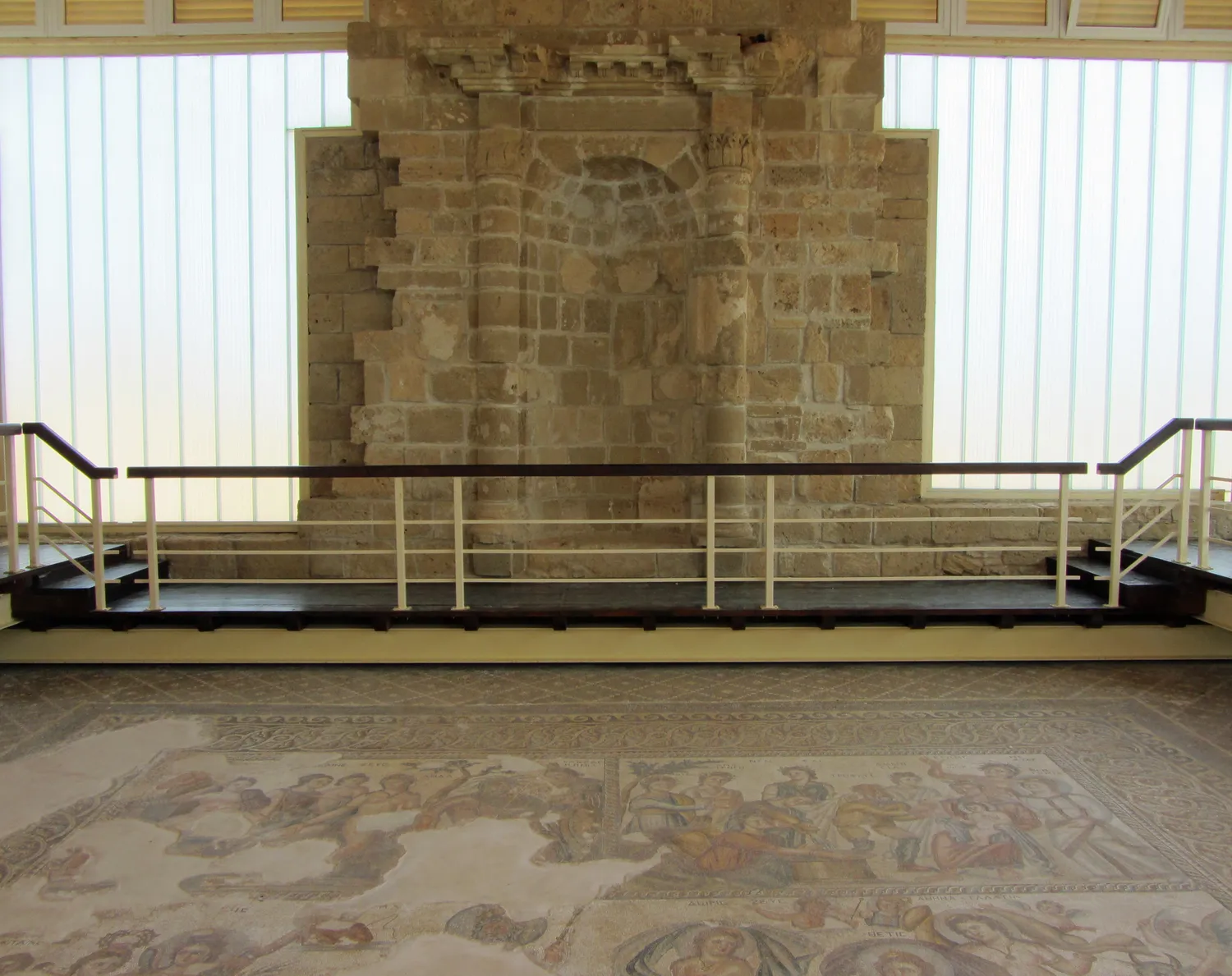
In autumn 1983 the Polish Mission found "a pile of architectural elements" that had fallen into the street in front of Room 69 of the villa. It was the wall of a house facing the villa, the House of Aion, and it has been restored to its original position: a semicircular statue niche with a half-column on either side and a cornice above [1, p. 63]. Only three rooms of the house have been fully cleared: a reception hall of 9 by 7.6 m and a vestibule with a tripartite entrance [1, p. 63]. The hall floor, laid around the middle of the 4th century AD, is described below [1, p. 71].
Reading a house from its floor
Mosaics as plans
A mosaic was laid on three layers of bedding, called statumen, rudus and nucleus. In the House of Dionysos the tesserae are about 1 cm across and cut from local stone, with glass used for bright orange, yellow, green and blue; the designs were probably taken from copy books [1, p. 14]. Most rooms have a marble drain-hole in the floor for the washing water [1, p. 13]. The House of Aion panels use tesserae of only 2 to 5 mm [1, p. 64].
Where the walls are gone, the floors become the plan. Kondoleon notes that "not a single entrance has been marked on the excavator's 1965 plan", so "the mosaics themselves indicate traffic patterns" [4, p. 10].
The dining room
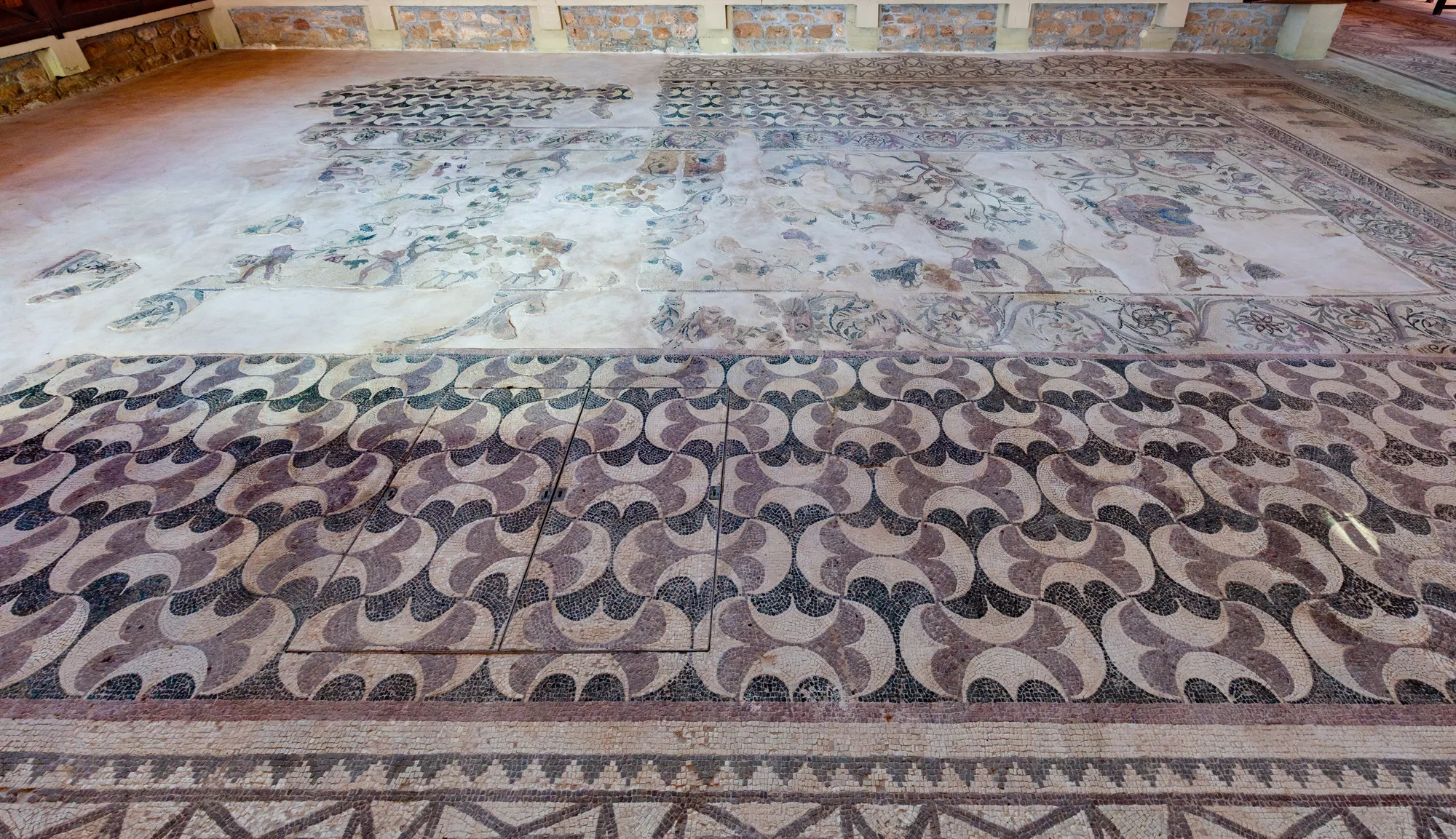
The great room of the House of Dionysos, about 11.50 by 8.50 m, was a tablinum used as a triclinium. A Triumph of Dionysos lies like a doormat at the entrance and a vintage scene fills the centre. Round three sides runs a band of peltae, with a meander band outside it. The couches, "arranged like a Greek Π", stood on the pelta band, and the outer band was a corridor for the servants [1, p. 24]. Kondoleon describes the panels as set in "the customary T-shape", with "a U-shaped geometric surround" marking where the three dining couches stood [4, p. 21] (see furniture). The reception hall of the House of Aion follows the same arrangement: five figured panels sit in a Π-shaped frame that opens towards the entrance [1, p. 63].
| House | Date | Size | Source |
|---|---|---|---|
| 'Hellenistic' House, Nea Paphos | Last phase late 1st to early 2nd c. AD | About three-quarters of an insula | [3] |
| House of Dionysos, Nea Paphos | Late 2nd c. AD (dates disputed) | c. 2,000 m², over 40 rooms | [1, p. 11]; [4, p. 9] |
| Villa of Theseus, Nea Paphos | From 2nd half of 2nd c. AD to early 7th c. | Over 120 by 80 m | [1, p. 52] |
| House of Aion, Nea Paphos | Floor mid-4th c. AD | Hall 9 by 7.6 m | [1, pp. 63, 71] |
| House of the Gladiators, Kourion | Later 3rd c. AD | c. 1,110 m² | [5, pp. 14, 43] |
| Earthquake House, Kourion | Destroyed later 4th c. AD | c. 397 m² | [5, pp. 15, 43] |
The Earthquake House at Kourion
Walls, floors and roofs
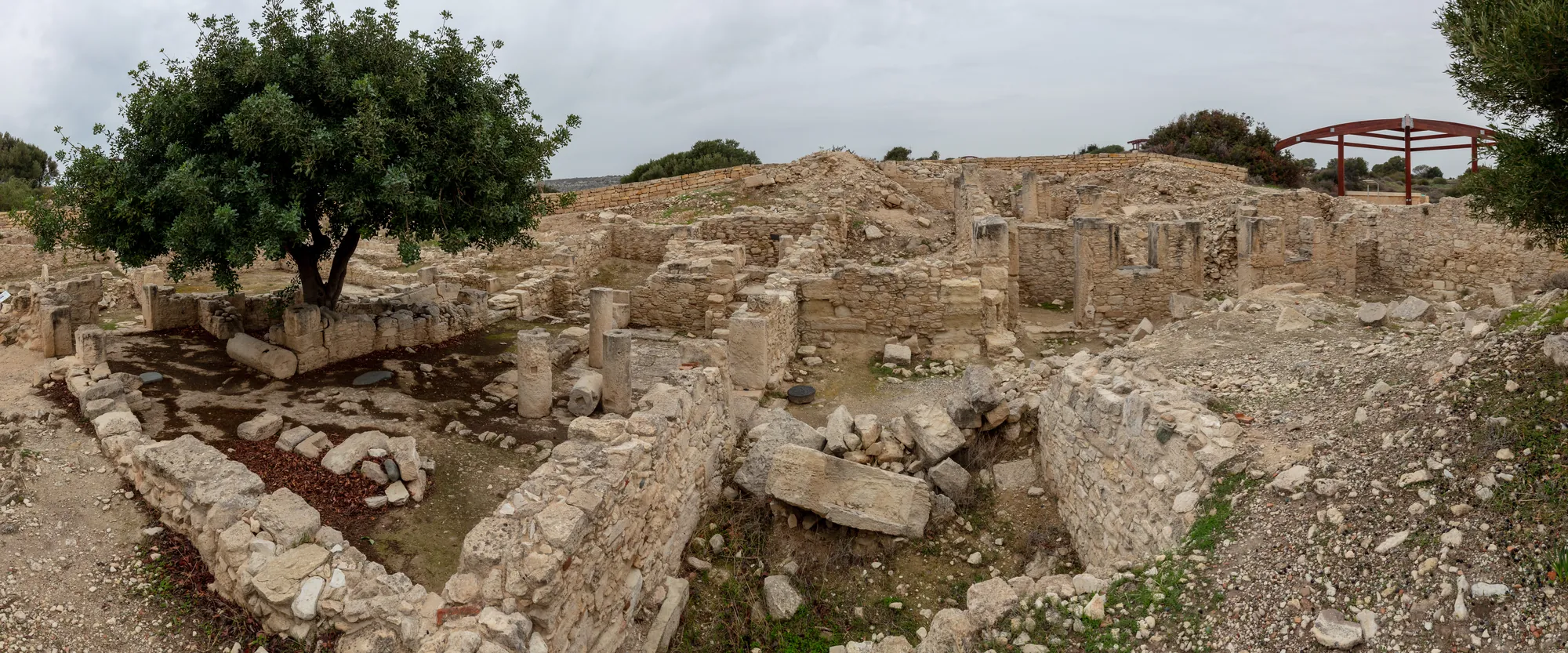
The Earthquake House lies on the south-eastern edge of the Kourion acropolis. It was excavated by David Soren and re-studied by Benjamin Costello IV, and it is rebuilt in the Earthquake House reconstruction. Its foundations are about 30 to 60 cm thick, of dressed and undressed limestone blocks, some reused, laid in irregular courses with mud mortar and chinked with limestone fragments and sometimes pottery. The debris held a great deal of decayed mudbrick, so Costello reads the house as "a hybrid construction with stone foundations supporting a mudbrick superstructure, a technique that continues to be used in Cyprus today" (see building materials and techniques) [5, p. 31].
The walls had mud plaster and no painted plaster. Doorways were built to a standard pattern, with large threshold blocks and jambs of ashlar or big slabs. Floors were plain compacted earth, often lower than the thresholds, so stone steps were set inside the doors [5, p. 32]. Most of the house had flat or gently sloping roofs "based on traditional Cypriot construction techniques": main beams the length of the room, smaller cross-beams, then branches, sticks, reeds, matting and packed mud [5, p. 32].
Room 8, 7.65 by 6.40 m, was the largest covered room and "the only one possessing a tile roof at the time of destruction". Its central support was a stack of six limestone slabs, each about 52 cm square, rising 1.14 m, with two column drums on top, for a total height of 3.24 m. The roof probably had a north to south ridge and sloped east and west at about 22.5°. About 250 iron nails were found, and the Corinthian-type cover tiles (imbrices) were cemented to the pan tiles (tegulae) with lime plaster tempered with small river gravel [5, pp. 34-35]. One step was an upside-down pilaster capital, and an alabaster table top of about 110 kg stood on limestone legs [5, p. 35]. Rooms 6 and 7 were full of decayed mudbrick, but held too few tiles to roof them; Costello takes them as patch repairs and rejects the published reconstructions that tile these rooms [5, pp. 38-39].
Court, stair and upper floor
The first house was a paved courtyard with an L-shaped colonnade of 41.56 m² (Rooms 15 and 18), Rooms 1 and 8, and a west suite of Rooms 12, 14 and 19, entered from an alley on the north [5, pp. 33-34]. The court was paved with squared limestone blocks, some reused. Six unfluted Doric columns, their spacing "noticeably irregular" and their drums and capitals partly reused, carried a colonnade roof of wood and mud. The colonnade had already collapsed before the earthquake [5, pp. 33-34].
An L-shaped stone stair rose four steps west to a landing, then turned south for four more. Its parallels at Meiron, Agios Kononas and Pella all led to upper floors, and Costello concludes that "both the architecture and material evidence indicate the presence of a second story over at least a portion of the structure" [5, p. 34]. The stair continued in timber over Room 19 [5, p. 37]. Upper storeys are inferred in every house on this page: from stairs at Kourion and in parts of the Villa of Theseus, and from beam sockets and taller porticoes in the 'Hellenistic' House. None survives standing.
Room 14 had a hemispherical mudbrick oven "similar to those still used in Cyprus today" [5, p. 36]. Two additions followed, the second with an open yard of 7.7 by 13.4 m [5, p. 37], and rooms were later subdivided, "a common phenomenon during Late Antiquity" [5, p. 39].
A non-elite house
Soren labelled the rooms from Vitruvius, Xenophon and Pliny, whose texts describe idealised elite houses, and read the building as an upper-scale residence in decline. Costello leaves the rooms unlabelled [5, p. 31] and concludes that "the evidence does not support the excavator's interpretation". He sees a non-elite "vernacular" house, a "fusion of Greco-Roman and traditional Cypriot elements" with its nearest parallels at Kalavasos-Kopetra and Agios Kononas of the 6th and 7th centuries. At its greatest extent it covered about 397 m². Its inhabitants stood at the "lower end of the socio-economic scale" but were "not completely without means" [5, pp. 42-43].
Kourion also had elite houses. In the later 3rd century AD the House of the Gladiators and the House of the Apsed Triclinium, both peristyle houses and perhaps one complex, rose on the north-west of the acropolis [5, p. 14]. The House of the Gladiators, with its mosaics, covered about 1,110 m², 2.79 times the size of the Earthquake House [5, p. 43].
The date of the destruction is debated. Soren dated it by coins to the earthquake that Ammianus records for 21 July 365. Costello calls this "convincingly challenged and largely invalidated", because coins of Valens took time to reach circulation and the epicentre of the 365 earthquake lay off western Crete, about 860 km away. He proposes "sometime during the later 4th century AD, possibly ca. AD 370-380" [5, p. 15]. Kourion was abandoned and reoccupied in the early 5th century [5, p. 15]. The wider sequence is covered under earthquakes and in the course lesson how buildings fall.
Warehouses and water
Dreamer's Bay
On the Akrotiri peninsula, fieldwork from 2015 to 2019 re-examined a line of shoreline buildings spread along about half a kilometre west of Dreamer's Bay. They had "stone-foundations probably supporting mudbrick superstructures. At least some had ceramic tile roofing". They are long, narrow buildings, about 4.4 to 6.5 m wide and up to about 50 m long, with walled courtyards, all on one alignment [6]. Earlier readers dated them to the 5th and 6th centuries and placed a port town behind them. Simon James and his colleagues found no LR1 amphorae in the stratified building deposits and date the buildings from as early as the 2nd century AD, in use in the 3rd and sealed perhaps by the end of the 4th, on an old Hellenistic landing place. In Structure 5 the dividing walls fell westwards onto amphorae and cooking pots, "very likely the same mid-4th century event which devastated Kourion". Amphorae, a weight, nails and a sailmaker's needle point to stores and workshops, perhaps with lodgings for crews. "The inferred residential district behind the 'warehouses' did not exist" [6].
Cisterns, pipes and conduits
Rich and modest houses alike stored rainwater. In the House of Dionysos the roofs of the atrium sloped inward (compluvium) to an impluvium, underground lead pipes carried the water into cisterns, and the drains joined a main drain under the north street [1, p. 13]. In the Villa of Theseus surplus water from the atrium went to cisterns [1, p. 53], and in the 'Hellenistic' House the gutter-cornice fed the impluvium and tanks [3]. The Earthquake House had a cistern in Room 12A, lined with hydraulic plaster and holding at least 5.00 m³ [5, p. 36].
At Kourion, Costello thinks it probable that a first aqueduct, the West Conduit, was built in the early 1st century AD to bring water about 11 km from a source near Sotira, though "this hypothesis [has] not been archaeologically confirmed" [5, p. 13]. When the Antonine stadium was built over it, the line was moved, and a second line, the East Conduit, brought water from a spring near Souni along a winding route of about 22 km, entering the city on an aqueduct bridge 60 m long and up to 5 m high [5, p. 14]. The town's baths are described under theatres, baths and public buildings and in the Roman bath reconstruction.
References
- 1.Daszewski, W. A., & Michaelides, D. (1988). Guide to the Paphos mosaics. Bank of Cyprus Cultural Foundation, in collaboration with the Department of Antiquities.
- 2.Młynarczyk, J. (1996). Palaces of strategoi and the Ptolemies in Nea Paphos: Topographical remarks. In W. Hoepfner & G. Brands (Eds.), Basileia: Die Paläste der hellenistischen Könige. Philipp von Zabern.
- 3.Brzozowska-Jawornicka, A. (2021). 'Hellenistic' House in Nea Paphos, Cyprus: A first summary of its architecture. Études et Travaux, 34.
- 4.Kondoleon, C. (1995). Domestic and divine: Roman mosaics in the House of Dionysos. Cornell University Press.
- 5.Costello IV, B. (2014). Architecture and material culture from the Earthquake House at Kourion, Cyprus: A Late Roman non-elite house destroyed in the 4th century AD (BAR International Series 2635). Archaeopress.
- 6.James, S., Blue, L., Rogers, A., & Score, V. (2021). From phantom town to maritime cultural landscape and beyond: Dreamer's Bay Roman-Byzantine 'port', the Akrotiri Peninsula, Cyprus, and eastern Mediterranean maritime communications. Levant. https://doi.org/10.1080/00758914.2021.1887647