
Agios Sozomenos
An archaeological exploration of Agios Sozomenos, a Bronze Age settlement in Cyprus. This article contextualizes the site within the broader framework of the Cypriot Bronze Age, discussing settlement characteristics, economy, and social organization.
Reassessing Agios Sozomenos: Fortifications, Economy, and Society in Bronze Age Central Cyprus
In the central Mesaoria Plain of Cyprus, the landscape is punctuated by a steep plateau that rises abruptly above the confluence of the Alykos and Gialias river valleys [1, p. 159]. This strategic location is home to a cluster of Bronze Age sites known collectively as Agios Sozomenos. For decades, this complex has been central to discussions about the island’s socio-political development during the transition from the Middle to the Late Bronze Age (c. 1750–1200 BCE), a period of increasing social complexity, metallurgical production, and international trade [2, p. 157; 3, p. 185]. Early interpretations suggested Agios Sozomenos was a major regional center that was eventually superseded by the nearby city of Idalion [1, p. 239]. However, recent research indicates a more intricate reality, revealing a network of specialized sites, including imposing fortifications and settlements engaged in a diverse economy. This article will examine the archaeological evidence from the Agios Sozomenos complex to reconstruct its chronological development and material culture. It will analyze the function of its fortifications and settlements, explore its multifaceted economy, and situate its rise and eventual abandonment within the broader context of Bronze Age Cyprus and its relationship with the later urban center of Idalion.
A Contested Landscape: A History of Investigation
The archaeological importance of Agios Sozomenos has been recognized for a century. In 1924, the Swedish Cyprus Expedition under Einar Gjerstad excavated a building at the locality Glyka Vrysi, which he interpreted as a fortress measuring 19 by 8.3 meters [4, p. 31]. Decades later, surveys conducted by Hector Catling in the 1950s revealed a high concentration of Middle and Late Bronze Age sites across the plateau and the surrounding lowlands [1, p. 238; 5, p. 126]. Catling’s work established the long-held theory that Agios Sozomenos was the primary Middle and Late Bronze Age settlement in the valley, a position it later yielded to Idalion [1, p. 239].
More recent and systematic investigation has been undertaken by the Department of Antiquities, Cyprus, through the Agios Sozomenos Excavations and Survey Project (ASESP), directed by Despina Pilides [1, p. 238; 6, p. 257]. This project aims to re-evaluate previous work and provide a more comprehensive understanding of the settlement patterns, the chronological relationship between the various sites, and the specific function of the prominent fortifications on the plateau [6, p. 257]. Combining survey data with targeted excavations, this modern research has begun to refine the picture of a complex system of interdependent sites, moving beyond the simple model of a single, dominant center [1, p. 238; 6, p. 257; 7, p. 21]. The evidence now points to a cluster of fortified enclosures, settlements, and workshop areas that collectively controlled a vital corridor in central Cyprus.
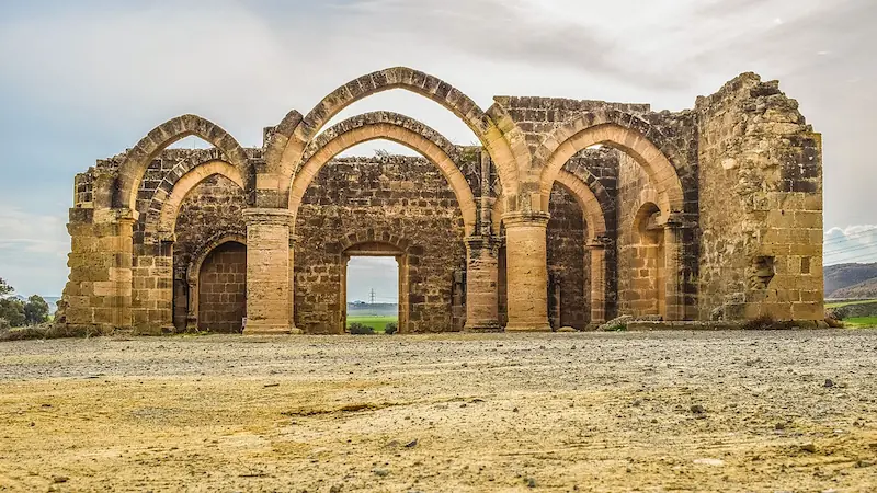
The Fortification System: A Network of Control
The most striking feature of the Agios Sozomenos landscape is the collection of four fortified sites dating to the Middle Cypriot III–Late Cypriot IA period (c. 1750–1600 BCE) [1, p. 159; 4, p. 18]. Three of these—Barsak, Nikolides, and Dhali Kafkallia—are perched atop the 40–50 meter high cliffs of the plateau, while a fourth, Glyka Vrysi, sits at the base near a freshwater source [1, p. 159]. These were not isolated strongholds but components of an integrated defensive system that capitalized on the natural topography.
The site of Agios Sozomenos-Barsak featured a formidable double circuit wall, each section measuring 2 meters wide, with a deep ditch on the exterior [4, p. 24; 1, p. 239]. At the east corner of the northern enclosure, excavators identified the substructure of a tower built with massive blocks [4, p. 24]. Finds from Barsak are characteristic of the Middle Cypriot period, including Red Polished, Red Slip, and Black Slip pottery sherds from small vessels [4, p. 24].
Approximately 2 kilometers to the southwest lies Agios Sozomenos-Nikolides, a fortified settlement on a steep, rocky hillock [4, p. 24]. It was encircled by a 900-meter-long enclosure wall, 2 to 3.2 meters wide, constructed of rough ashlar blocks. Recent excavations at its northeast corner have unearthed the foundations of a rectangular tower (15 by 7.5 meters) built with regular ashlar blocks [4, p. 24; 1, p. 239]. The existence of extensive internal structures remains unclear, though several perpendicular walls have been detected along the eastern and southern sections of the enclosure [4, p. 24].
Dhali Kafkallia is a fortified settlement composed of two conjoined enclosures, one of which contains evidence of domestic architecture [1, p. 159]. This site, along with Nikolides, featured towers as part of its defensive system [1, p. 159]. The fourth site, Agios Sozomenos-Glyka Vrysi, is the location of the structure first identified as a fort by Gjerstad [4, p. 31]. Located at the base of the cliffs, it appears to have functioned as a fortified outpost guarding the nearby water source and a small settlement [1, p. 159]. Some scholars have noted architectural similarities between the building at Glyka Vrysi and the massive "fortresses" at the major coastal center of Enkomi, suggesting they may have served similar military functions, possibly to secure copper transport and processing [4, p. 18].
The function of this network of fortifications is a key area of scholarly debate. The sites collectively overlook well-watered, fertile farmland and control access to the Gialias river valley, a major communication route to the east [1, p. 159]. Their combined viewsheds create a near-360-degree surveillance capacity over a large portion of the Mesaoria Plain [1, p. 159]. This suggests the forts were built to monitor and manage the movement of people, raw materials, and processed goods across this critical region [1, p. 159]. Some researchers have proposed that the forts were part of a system of secondary sites linked to the primary coastal settlement of Enkomi, securing its access to the agricultural and mining resources of the hinterland [1, p. 239]. The evidence for supra-regional political organization is strong, though whether Agios Sozomenos was itself a primary center or an instrument of another polity remains an open question [1, p. 239]. The current state of knowledge suggests the fortifications, despite their strong walls, have yielded relatively few finds, and excavations within the enclosures have yet to reveal significant architecture in some cases, raising further questions about their precise use [4, p. 19].
Life and Labor: The Economy of an Inland Hub
The power projected by the forts was connected to a vibrant economic life in the settlements at the foot of the plateau. Excavations at localities named Tzirpoulos and Ampelia have revealed settlement architecture with evidence for storage and economic activities [4, p. 19]. The finds from these sites suggest that the Agios Sozomenos complex was not solely a military outpost but a productive center with a diverse economy based on agriculture and craft production.
An Agricultural and Pastoral Base
The strategic location of the Agios Sozomenos sites provided access to well-watered farmland and pastures suitable for cattle, sheep, and goats [1, p. 159]. While direct archaeobotanical evidence from the site is not detailed in the available sources, the broader context of the Late Bronze Age Cypriot economy points to the importance of agricultural surplus. Major centers like Kalavasos-Ayios Dhimitrios and Alassa-Palaeotaverna had extensive, centralized storage facilities, particularly for olive oil [3, p. 185; 2, p. 157; 8, p. 327]. The presence of impressive storage pithoi at these sites, some holding thousands of liters, indicates that agricultural products were a cornerstone of elite wealth and a key commodity in regional and international exchange networks [3, p. 185]. It is reasonable to assume that the agricultural potential of the Gialias valley was a primary factor in the establishment and prosperity of the Agios Sozomenos complex, which likely produced staples for both local consumption and trade [1, p. 239; 8, p. 327].
Textile Production
Archaeological indicators of textile production, such as spindle whorls and loom weights, are common at Bronze Age Cypriot sites, although the organic materials of the craft—fibers, yarns, and finished cloth—rarely survive [9, p. 305]. Textile manufacturing was a significant economic activity, ranging from household production to more specialized, workshop-based operations [9, p. 305; 10, p. 57]. Evidence for specialized production comes from sites like Pyrgos, where industrial and storage areas contained equipment for textiles alongside metal furnaces and olive oil jars [11, p. 53; 12, p. 4]. At Kition, permanent textile installations operated in both sanctuary and residential areas during the transition from the Late Bronze to Early Iron Age [13, p. 24; 14, p. 5]. At Agios Sozomenos, excavations at Tzirpoulos have revealed part of a large building with evidence of "intense workshop activities" spanning from the beginning of Late Cypriot I to Late Cypriot II [6, p. 257; 1, p. 239]. While the specific crafts are not fully detailed, the presence of a workshop complex fits a broader pattern of specialized production becoming more organized across the island, with textiles likely being a key component of the local economy [15, p. 213; 16, p. 22].
Metallurgy and Trade
The role of Agios Sozomenos in the Cypriot copper industry is a central element of its interpretation. Since most Middle Bronze Age settlements are located in the metal-rich Troodos foothills, copper extraction was clearly a major factor in the economy of the period [17, p. 150]. It is argued that inland sites like Agios Sozomenos were likely involved in the production of copper and its transport to coastal ports for export [7, p. 14; 18, p. 14]. This trade with regions like Crete, Egypt, and Mesopotamia is thought to have intensified around 1750 BCE, coinciding with the establishment of the Agios Sozomenos forts [7, p. 14].
Direct evidence for large-scale copper smelting is often elusive at Late Bronze Age sites, with the exception of major centers like Enkomi [19, p. 114]. However, remains of smaller-scale, localized metallurgical activity, such as slag concentrations and crucible fragments, are found at nearly every known settlement of the period, including Kalavasos-Ayios Dhimitrios [19, p. 114; 20, p. 41; 3, p. 232]. At Agios Sozomenos, Catling’s survey at Ampelia recovered fragments of bronze objects [1, p. 238]. The defensive posture of the forts has been interpreted as a measure to secure the transport and processing of this valuable commodity [4, p. 18]. The site of Analiondas Palioklishia, located near the source of the Alykos River, has been identified as an agricultural production and storage center from the 13th century BCE, possibly operating as a support village within a regional exchange system connected to Agios Sozomenos and, ultimately, to a coastal hub [1, p. 239; 2, p. 147]. This suggests a hierarchical system where inland sites managed the procurement of both agricultural goods and metals for larger political entities.
Chronology and a Place in the Wider World
Establishing a precise chronology for the Agios Sozomenos complex is challenging, but a general sequence can be constructed from the available data. The fortifications on the plateau are dated to the Middle Cypriot III–Late Cypriot IA periods (c. 1750–1600 BCE) [1, p. 159; 4, p. 34]. The settlement at Tzirpoulos has at least two phases of use, running from Late Cypriot I through Late Cypriot II [6, p. 257]. Overall, the archaeological landscape shows continuous occupation from the Middle Bronze Age into the Late Bronze Age [7, p. 10]. A critical chronological marker is the abandonment of the site cluster before the end of the Late Cypriot II period, and more specifically before the LCIIC phase (post-1300 BCE), which was a time of peak urban development at other major Cypriot centers [1, p. 239].
The material culture recovered from Agios Sozomenos demonstrates that the complex was far from isolated. The surface finds from Ampelia included imported Canaanite jars and Levantine ceramics, as well as Late Helladic IIIA-B vases from the Aegean [1, p. 238]. Fragments of prestige goods like faience and ivory were also identified [1, p. 238]. These artifacts firmly place the site within the extensive international exchange networks that characterized the Late Bronze Age eastern Mediterranean [21, p. 9]. The presence of such goods in an inland location supports the theory that Agios Sozomenos functioned as an important node in the flow of commodities, acting as an entrepôt for trade between coastal port towns and more remote settlements to the north and northwest [1, p. 239]. The debate continues as to which major coastal power it was primarily connected. Catling suggested the rich port towns in the Larnaka region [1, p. 239], while others have convincingly argued for a link to Enkomi, for which the Gialias River provided a direct route into the agricultural and mineral-rich hinterland [1, p. 239].
From Agios Sozomenos to Idalion: A Regional Shift
The abandonment of the Agios Sozomenos site cluster before the end of the Late Cypriot II period marks a significant turning point in the history of the region [1, p. 239]. This event appears to coincide with the rise of the nearby settlement of Idalion, which lies a short distance away in the Gialias valley. Archaeological evidence indicates a chronological overlap between the latest excavated period at Agios Sozomenos and the earliest remains found at Idalion [7, p. 14; 18, p. 14]. This has led to the long-standing hypothesis that the political and economic focus of the region shifted from one center to the other [1, p. 239].
The reasons for this transition are not explicitly stated in the archaeological record, but it represents a fundamental reorganization of the settlement pattern and power structure in central Cyprus. While the fortified complex at Agios Sozomenos seems to have failed to maintain its territorial organization into the climax of the Late Bronze Age, Idalion went on to thrive [1, p. 239]. Excavations at Idalion show evidence of continuity from the Late Bronze Age through the Iron Age and into the Roman period, eventually developing into one of the island's major city-kingdoms [7, p. 10; 22, p. 12; 23, p. 16]. The decline of the expansive, multi-sited complex at Agios Sozomenos and the consolidation of power at the single urban center of Idalion is a compelling case study of state formation and the dynamic nature of settlement hierarchies in ancient Cyprus.
Conclusion
The Bronze Age complex at Agios Sozomenos was more than a simple settlement or an isolated fort. The evidence reveals a sophisticated system of fortified enclosures, settlements, and workshops strategically positioned to control a fertile river valley and key trade routes through the heart of Cyprus. For centuries, during the critical transition from the Middle to the Late Bronze Age, its inhabitants managed a diverse economy based on agriculture, craft production, and likely the extraction and trade of copper. Its participation in the international exchange networks of the eastern Mediterranean is confirmed by the presence of imported ceramics and luxury goods.
The study of Agios Sozomenos challenges simplistic, unilinear models of Cypriot socio-political development. It highlights the crucial role of inland centers in the island's economy and their complex relationship with the major coastal polities. However, significant questions remain. Was the complex an autonomous regional power, or was it a network of secondary sites administered by a larger coastal center like Enkomi? The evidence supports both possibilities, and this remains a central point of scholarly debate [1, p. 239]. Furthermore, the specific factors that led to its abandonment just as other Cypriot centers were reaching their zenith are still not fully understood. The ongoing work of the Agios Sozomenos Excavations and Survey Project will undoubtedly continue to illuminate the history of this important landscape, offering new insights into the organization of power, production, and society in Bronze Age Cyprus [18, p. 21; 6, p. 257].
References
- 1.Kearns, C., & Manning, S. W. (Eds.). (2019). New directions in Cypriot archaeology. Cornell University Press.
- 2.Andreou, G. M. (2016). Understanding the Rural Landscape of Late Bronze Age Cyprus: A Diachronic Perspective from the Vasilikos Valley. Journal of Mediterranean Archaeology, 29(2), 143-172. http://dx.doi.org/10.1558/jmea.v29i2.32570
- 3.Knapp, A. B. (2008). *Prehistoric and protohistoric Cyprus: Identity, insularity, and connectivity.* Oxford University Press.
- 4.Hansen, S., & Krause, R. (Eds.). (2019). *Bronze Age fortresses in Europe: Proceedings of the Second International LOEWE Conference, 9-13 October 2017 in Alba Julia* (Universitätsforschungen zur prähistorischen Archäologie, Vol. 335). Verlag Dr. Rudolf Habelt GmbH.
- 5.Devillers, B. (2008). Holocene morphogenesis and anthropisation of a semi-arid watershed, Gialias River, Cyprus (BAR International Series, No. 1775). BAR Publishing. https://doi.org/10.30861/9781407302638
- 6.Otto, A. (Ed.). (2018). The 11th International Congress on the Archaeology of the Ancient Near East: Programme. Ludwig-Maximilians-Universität.
- 7.Schmid, S. G., & Kennedy, W. M. (Eds.). (2024). *The topography of ancient Idalion and its territory*. Logos Verlag Berlin.
- 8.Bourogiannis, G. (Ed.). (2022). *Beyond Cyprus: Investigating Cypriot connectivity in the Mediterranean from the Late Bronze Age to the end of the Classical Period* (AURA Supplement No. 9). National and Kapodistrian University of Athens, Faculty of History and Archaeology.
- 9.Bolger, D., & Serwint, N. (Eds.). (2002). *Engendering Aphrodite: Women and society in ancient Cyprus*. American Schools of Oriental Research.
- 10.Aulsebrook, S., Żebrowska, K., Ulanowska, A., & Lewartowski, K. (Eds.). (2022). Sympozjum Egejskie: Papers in Aegean Archaeology (Vol. 3, Warsaw Studies in Archaeology). Brepols Publishers. https://doi.org/10.1484/M.WSA-EB.5.128786
- 11.Pilides, D., & Papadimitriou, N. (Eds.). (2012). *Ancient Cyprus: Cultures in dialogue*. Department of Antiquities, Cyprus.
- 12.Webb, J. M., & Frankel, D. (n.d.). Early and Middle Bronze Age (2500-1650 BC). In *Ancient Cyprus - Cultures in Dialogue* (pp. 51-55).
- 13.Fourrier, S., & Hermary, A. (Eds.). (2019). Cahiers du Centre d’Études Chypriotes 49. Diffusion De Boccard.
- 14.Centre d’Études Chypriotes. (2019). *Cahiers du Centre d’Études Chypriotes*, *49*. Diffusion De Boccard.
- 15.Knox, D.-K. (2012). *Making sense of figurines in Bronze Age Cyprus: A comprehensive analysis of Cypriot ceramic figurative material from EC I – LC IIIA (c.2300BC – c.1100BC)* [Doctoral dissertation, The University of Manchester].
- 16.Hadjikyriakos, I., & Trentin, M. G. (Eds.). (2015). *Cypriot cultural details: Proceedings of the 10th Post Graduate Cypriot Archaeology Conference*. Oxbow Books.
- 17.Gagné, L. A. C. (2012). Middle Cypriot White Painted Ware: A study of pottery production and distribution in Middle Bronze Age Cyprus [Doctoral dissertation, University of Toronto].
- 18.Schmid, S. G., & Kennedy, W. M. (Eds.). (2024). The topography of ancient Idalion and its territory. Logos Verlag Berlin.
- 19.Kakoulli, I., & Walton, M. (Eds.). (2014). *40th International Symposium on Archaeometry ISA 2014 Program and Abstract Book* (40th International Symposium on Archaeometry, Los Angeles, CA). Getty Conservation Institute; Cotsen Institute of Archaeology; University of California, Los Angeles.
- 20.Parpas, A. P. (2022). *The maritime economy of ancient Cyprus in terms of the new institutional economics*. Archaeopress Publishing Ltd.
- 21.Vavouranakis, G. (Ed.). (2011). *The seascape in Aegean prehistory* (Monographs of the Danish Institute at Athens, Vol. 14). Aarhus University Press.
- 22.Gaber, P. (2008). Excavations at Idalion and the changing history of a city-kingdom. *Near Eastern Archaeology, 71*(1–2), 52–67.
- 23.Schmid, S. G., & Kennedy, W. M. (Eds.). (2024). The topography of ancient Idalion and its territory (Studia Cyprologica Berolinensia, Vol. 2). Logos Verlag Berlin.