
Research·In brief
Network study of 299,171 km of Roman roads puts Byzantium and Antioch ahead of Rome
Timing each road for a walker, an Aarhus-led team finds the Empire's most central overland path ran from Lepcis Magna via Antioch and Byzantium to Narbo.



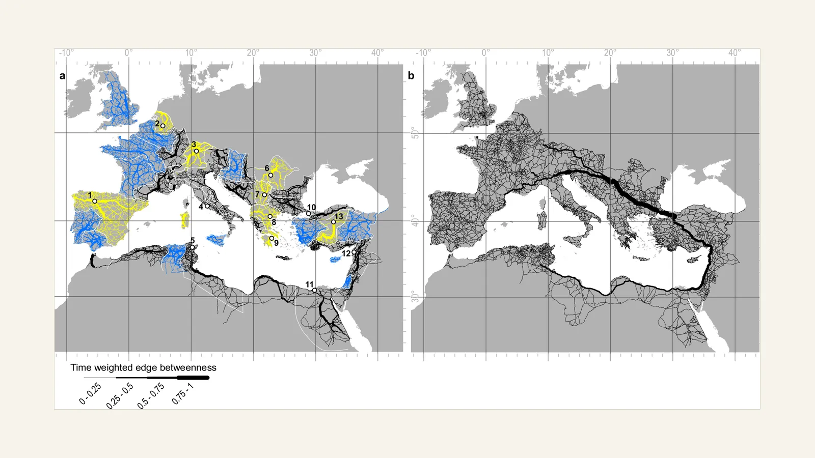
Byzantium, Antioch, Ancyra and Corinth were better placed than Rome as stopping points for overland travel across the Roman Empire, according to a network analysis by Adam Pažout, Tom Brughmans and colleagues at Aarhus University, published in Nature Communications on 15 September 2026.
The team turned 299,171.31 km of mapped Roman roads into a network of junctions and segments, timed each segment for a walker over the terrain, and counted how many of the quickest routes between all points use each road. The top-scoring path runs from Lepcis Magna past Alexandria, Caesarea Maritima and Antioch, through Nicomedia to Byzantium, where a modelled ferry over the Bosporus joins the Asian and European roads, then on by Serdica and Aquileia to Narbo. The Italian peninsula, the authors write, is "an appendix" to that path. Of the 45 provincial capitals, 24 fall in the top two deciles empire-wide.
The model covers land routes only; for most long-distance transport the authors point to rivers and the sea, on which Rome is highly central. Great Britain and the Mediterranean islands form small networks of their own, and the paper's map shows Cyprus as one. In Roman Cyprus the western roads around Nea Paphos and the eastern ones around Salamis were joined by highways along the north and south coasts only shortly before or after the annexation, and milestones record major repairs to that coastal highway in 198 CE [1, p. 13].
Original source
On ancientcyprus.com
- Sites
- Nea Paphos, Salamis
- Institutions
- Aarhus University
- Periods
- Roman
References
- 1.Bekker-Nielsen, T. (2013). Transport in ancient Cyprus. In M. L. Lawall & J. Lund (Eds.), The Transport Amphorae and Trade of Cyprus. Aarhus University Press.
More in Research
- University of Cyprus to lead €4.3m EU pottery network that will recruit 15 PhD researchers
- Pyla-Koutsopetria survey volume is a free download, hyperlinked to the finds data behind it
- Silver bowl from Amathus may carry the earliest known picture of a hoplite phalanx
- Athens' 200 triremes were built partly with timber from Cyprus, study says
- Two Jerusalem toilets of the 7th–6th century BCE held Giardia, a diarrhoea parasite