
Unnumbered pageScan 10 of 87
18
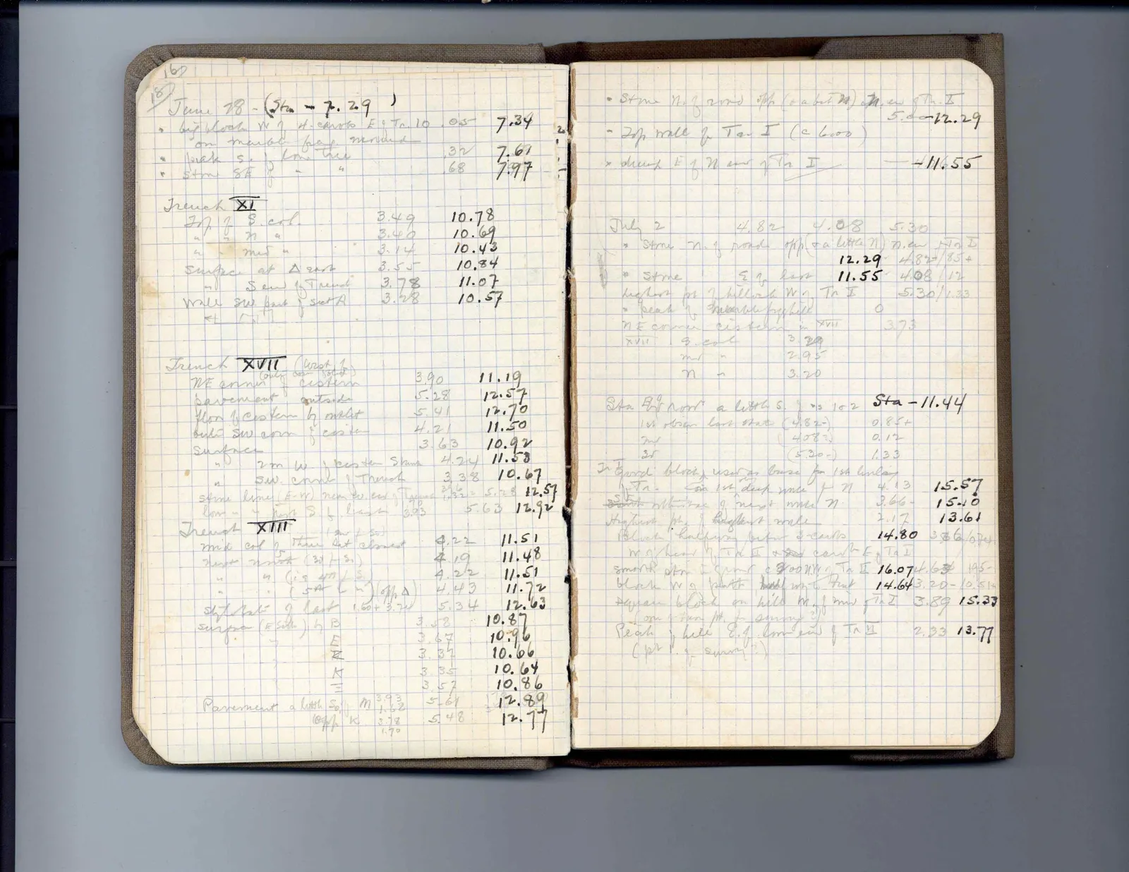
June 18(Sta - 7.29)
| " | big block W. of S.-curbs E. of Tr. I C | 05 | 7.34 | ||
| " | " on marble frag. near mid | 32 | 7.61 | ||
| " | rock S. - low tree | 38 | 7.67 | ||
| " | stone S.E. " " | 68 | 7.97 |
<u>Trench XI</u>
| Top of S. col. | 3.49 | 10.78 | ||
| " " " " | 3.40 | 10.69 | ||
| " " mid " | 3.14 | 10.43 | ||
| surface at A east | 3.55 | 10.84 | ||
| " S. end of trench | 3.78 | 11.07 | ||
| wall SW part of sect A | 3.28 | 10.57 |
<u>Trench XVII</u> (west of (only one found))
| NE corner cistern | 3.90 | 11.19 | ||
| pavement outside | 5.28 | 12.57 | ||
| floor of cistern by outlet | 5.41 | 12.70 | ||
| built SW corn of cistern | 4.21 | 11.50 | ||
| surface | 3.63 | 10.92 | ||
| " 2 m. W. of cistern SW corn | 4.29 | 11.58 | ||
| " SW. corn of trench | 3.38 | 10.67 | ||
| stone line (E-W) near toward of Trench | 3.96 [illegible] 5.28 | 12.57 | ||
| low " " " S of last 3.93 | 5.63 | 12.92 |
<u>Trench XIII</u>
| mid col of thin slat [illegible] | 4.22 | 11.51 | ||
| next north (3rd of S.) | 4.19 | 11.48 | ||
| " " (is 4th of S.) | 4.22 | 11.51 | ||
| " " (5th S.) [opp A] | 4.43 | 11.72 | ||
| stylobate of last 1.60+3.74 | 5.34 | 12.63 | ||
| surface (E side) by B | 3.58 | 10.87 | ||
| " E | 3.67 | 10.96 | ||
| " H | 3.37 | 10.66 | ||
| " K | 3.35 | 10.64 | ||
| " L | 3.57 | 10.86 | ||
| Pavement a little S of M 3.93 | 5.61 | 12.89 | ||
| " opp K 3.78 | 5.48 | 12.77 |
Right page
•stone N. of road opp (or a bit N) N.W of Tr. I 5.00-12.29
•Top wall of Tr. I (c 6.00)
•drain E of N end of Tr I -11.55
| July 2 | 4.82 | 4.08 | 5.30 | ||
| * stone N. of road opp (a little N) N. end Tr I | 12.29 | 4.82- | .85+ | ||
| * stone E of last | 11.55 | 4.08 | .12 | ||
| highest pt of hillock W of Tr I | 5.30 | 1.33 | |||
| • peak of hillock by field | 0 | ||||
| NE corner cistern in XVII | 3.73 | ||||
| XVII S. col. | 3.29 | ||||
| " m " | 2.95 | ||||
| " n " | 3.20 |
| Sta. E of road a little S. of S. of 102 | Sta - 11.44 | ||
| 1st observ. last stat (4.82-) | 0.85+ | ||
| 2nd (4.08-) | 0.12 | ||
| 3d (5.30-) | 1.33 |
| In yard block used as base for 1st leveler | ||||||
| Tr. low 1st deep wall of N. | 4.13 | 15.57 | ||||
| S wall at base of next wall N. | 3.66- | 15.10 | ||||
| Highest pt of highest wall | 2.17 | 13.61 | ||||
| Block halfway between S-curbs | 14.80 | 3.36 | 67+ | |||
| W of head of Tr I & 2nd curb E of Tr I | ||||||
| smooth stn in spur c 8.00 N W of Tr I | 16.07 | 4.63 | 1.95- | |||
| block W of south level W. of Tr. I find | 14.64 | 3.20- | 0.51+ | |||
| square block on hill W. of end of Tr I | 3.89 | 15.33 | ||||
| (one of two pts for survey?) | ||||||
| Peak of hill E. of lower of Tr II | 2.33 | 13.77 | ||||
| (pt I of survey?) |
65 figures hard to readstruck struck outadded written in above” jug ditto, and what it repeatsword reading not certain